Heavy downpours for NZ today & stormy weather late Fri/Sat? (+2 Images)
31/08/2015 11:23pm

> From the WeatherWatch archives
Updated 11:12am — Heavy rain has eased in Northland and Auckland with just a few lingering drizzle patches and increasing sunny/dry spells – but further south the rain is only just setting in to some areas.
As of 11am rain with heavy falls was pushing across Waikato and into King Country and Central Plateau and parts of Bay of Plenty and Coromandel Peninsula.
Rain is also pushing into the lower North Island and upper South Island. It’s also raining along the West Coast and into the Southern Alps to some degree.
WeatherWatch.co.nz head weather analyst Philip Duncan says there are two lows at play in the Tasman Sea right now. “We have a small but intense low near our west coast and this is heading south today. It’s this low that has brought the burst of wind and rain to northern NZ and is now moving that weather southwards”.
Mr Duncan says this low is working in tandem with a larger area of low pressure closer to eastern Australia and over the next 24 hours these two lows will merge into one system and cross all of New Zealand on Wednesday. “As we transition away from the humid wet northerly flow and into the cooler, showery, south west flow there may be a few heavy downpours and isolated thunderstorms moving in to western districts on Wednesday afternoon”.
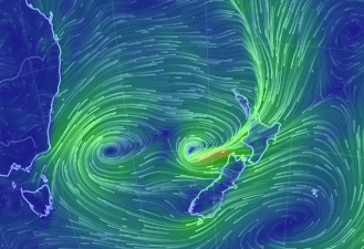
Image: Double Trouble – the two lows in the Tasman Sea can be clearly seen in this current wind map… you can also see the strong nor’east flow sweeping over the North Island and out to the west of Cook Strait. Both lows merge then clear NZ by Thurs AM…before the next low comes in on Friday PM/Saturday AM.
STORMY WEATHER RETURNS FRI/SAT?
On Thursday a low near Sydney (out in the western Tasman) will develop and start to deepen.
By Noon Friday this low will be rapidly deepening in the central Tasman Sea and will bring rain to western and northern NZ by night time. On Saturday winds may be gale force in a number of North Island regions with gusts to severe gale in the most exposed areas.
It may affect the entire North Island and upper South Island.
“Data that we trust from the US Govt and across Europe and Australia shows the low deepening quickly on Friday and across the weekend before departing out to our east on Sunday and Monday with a brief but cold southerly flow moving in, it’s certainly one to monitor” says Mr Duncan.
We’ll have more details in the coming days on any potential severe weather as a result of this spring set up.
There is some good news – the incoming low will be fast moving – which will reduce the chances of widespread problems. Some models also indicate Sunday could be quite sunny in some populated areas – but we don’t want to lock it all in for another day or so yet.
 Image / Small but intense and deep – one computer model we trust (from Australia) showing yet another deepening low bringing a burst of wind and rain to the North Island and upper South Island on Saturday morning.
– WeatherWatch.co.nz
Latest Video

Large low brings rain, downpours & some snow – gets colder as the week progresses
Low pressure will cross the upper North Island in the days ahead and that set-up actually pushes more heavy rain…
Related Articles
Large low brings rain, downpours & some snow – gets colder as the week progresses
Low pressure will cross the upper North Island in the days ahead and that set-up actually pushes more heavy rain…

WeatherWatch App launches real-time local lightning tracker!
A bolt out of the blue! WeatherWatch has launched a live, real-time lightning tracker, enabling Kiwis to gain access to data provided by the…

Polar airflow + northern low = pockets of heavy rain & snow
A colder change is coming – and so too is a large low which will develop and grow over northern…

