Heaviest rain this weekend patchy and isolated, winds more widespread (+6 Maps via IBM’s Deep Thunder)
27/04/2018 11:30pm

> From the WeatherWatch archives
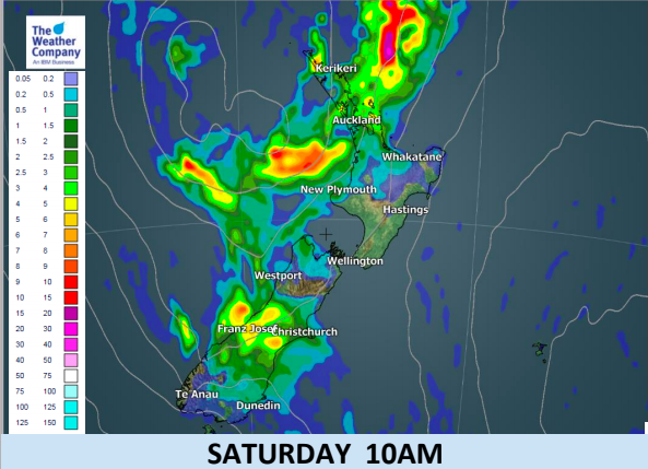
As strong winds slide down the upper North Island today ahead of the centre of the low that arrives Sunday a narrow band of rain is also sliding southwards with some isolated heavy falls.
This rain is mostly patchy and we expect totals may be lower than some expect. In saying that, there are some intense areas to monitor as the system heads southwards. The low will spread energy further afield on Sunday and this may likely weaken the rain bands later into Sunday although it will spread them further down into the South Island too.
Over the next 24 to 36 hours expect isolated heavy downpours here and there in both main islands.
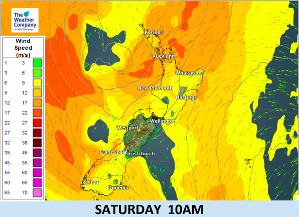
Strong winds are also head south and we expect a few more power cuts than normal in Auckland due to damage caused by the major storm over two weeks ago. Otherwise winds will hopefully remain just under the damaging threshold for most areas.
The six weather maps below have been generated by IBM’s Deep Thunder global model, exclusively for WeatherWatch.co.nz. IBM’s Deep Thunder crunches the data from 162 forecast models to produce these highly accurate maps for us.
Weather Highlights:
- Hours of rain (isolated heavy falls) and strong east to northeast winds are likely during Saturday in Northland.
- Heavier rainfall will start in Auckland about 12 Noon and may remain off and on until tonight. Heavy falls will be isolated.
- NE winds may exceed the limit of gale force (63km/h) in the same period for Northland and Auckland.
- There is an INCREASED risk of power outages due to the storm two weeks ago breaking branches which may fall from trees from this event (due to the winds coming from the opposite direction this time).
- Heavy rain will start later this afternoon in Bay of Plenty and may persist into Sunday morning.
- NE winds may exceed gale force at times in Bay of Plenty and Gisborne until Sunday morning.
- While there is some risk of a thunderstorm the risk is not considered high during this event.
- As the Low pressure system will stay off the west of Northland with areas of rain embedded around it,
- there will be other short-term rain events several times until Monday night (either as patchy areas of rain or in the form of long dry spells and showers).


WIND MAPS
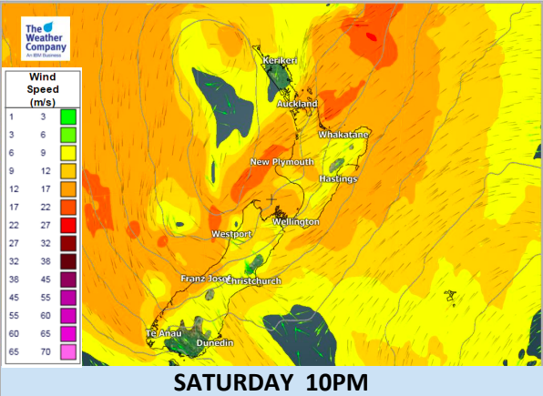
As you can see the winds increase (orange shading around Auckland’s coastal areas) into Saturday afternoon, then it eases back again later tonight. Wind maps measured in metres per second. The orange shading (or 12 to 17m/s) equals 43km/h to 61km/h (just shy of gale force). The much darker orange shading (or 17 to 22m/s) is gale force at 61km/h to 80km/h sustained. Gusts may exceed 100km/h. Most of this gale risk is coastal and around Great Barrier Island and northern Coromandel Peninsula but may brush some parts of Auckland.

– WeatherWatch.co.nz – Proudly an official IBM business partner
Latest Video

Update on incoming cold change for NZ
High pressure still covers NZ but that will slide offshore as we go into Friday and the weekend as a…
Related Articles
Update on incoming cold change for NZ
High pressure still covers NZ but that will slide offshore as we go into Friday and the weekend as a…

Wintry blast coming this weekend, everyone will feel the temperature drop
A significant cold change is coming in this weekend, starting as early as Friday for the lower South Island and…

Tracking the showers & a potential wintry blast late next week
NZ is on the edge of high pressure with anticyclones moving through at times over the next several days bringing…

