Further strong winds, heavy rain & snow for parts of the North Island, settled South Island (+10 Maps)
6/09/2018 1:33am

> From the WeatherWatch archives
A big area of high pressure is covering the South Island while the North Island is under an area of low pressure which is bringing heavy rain to the east and gusty winds in the southern half of the island. Strongest South East winds have been observed around Cook Strait and towards Taranaki and will remain for another 24 to 36 hours.
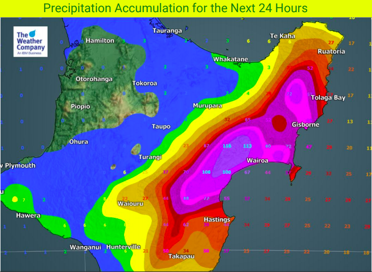
A front is also stretching from the low bringing heavy rain over the coastal areas of the eastern North Island, mainly Hawke’s Bay and Gisborne areas. Rainfall has been continuing around Hawke’s Bay and a further 100mm of rain is expected over the next 24 hours. Torrential downpours could lead to the rapid rise of river levels and flooding and slips will remain a possibility over the next day or two.
As the eastern rain is blown up and over Central Plateau in the SE flow it will fall as snow, heavy on the mountains and ranges. White out conditions in the mountains / tops of ranges is expected with snow and fog reducing visibility. This will be in remote areas for the most part.
Even though amounts of the precipitation begin to decrease on Thursday, the same pressure pattern and strong SE winds continue across Friday. High waves are expected as well, in the east of the North Island.
It’s a different story for most of the South Island enjoying mostly sunny days. Cold nights and frosts are giving way to mild afternoons. Frosts look likely to fade out or become lighter next week in the South Island.


– WeatherWatch.co.nz
Latest Video

Cold weekend, frosts return with high pressure, then a low late next week
The subantarctic airflow spreads over NZ today/tonight and into Saturday, dropping temperatures nationwide. Snow flurries are possible today to lower…
Related Articles
Cold weekend, frosts return with high pressure, then a low late next week
The subantarctic airflow spreads over NZ today/tonight and into Saturday, dropping temperatures nationwide. Snow flurries are possible today to lower…

Wintry burst of weather: Snow, squally showers then sunshine & frosts
A polar change (another one!) arrives on Friday for the South Island and goes nationwide on Saturday, leaving NZ under…

Antarctic southerly for parts of NZ Fri & Sat
For the first time this year a southerly from off Antarctica is heading towards the South Island, followed by more…

