
> From the WeatherWatch archives
WeatherWatch.co.nz says dry weather is stuck in place over the North Island and will likely remain that way for much of the month. The forecaster, using IBM data, projects a drier than average trend will continue across the North Island for at least half to two thirds of the month, with potential it could linger even longer
But even non-rain clouds have a silver lining and there is some optimism that high pressure may be sinking further south which not only gives the lower and western South Island a break from the wind and changeable weather, but also a chance of sub-tropical weather sliding further towards northern NZ.
Sub-tropical weather brings with it higher humidity and a higher chance of cloud with an increased chance of showers. It also tends to bring more easterlies which gives eastern areas a chance to cool down a little after weeks of scorching westerlies. A good example is Hawke’s Bay, which will be in the mid to late 30s for the first few days of the month, then a fairly simple easterly change mid week in the first week drops the highs by 10 degrees. Heat then shifts further inland and to the west.
But WeatherWatch.co.nz says the first week of February will feel like Autumn for some regions once the Aussie heatwave has moved through, especially in the South Island as storms in the Southern Ocean fire up rain bands, colder airflows and strong winds. But, it’s this southerly around Tuesday February 4th that may drive in some welcome rain to dry eastern areas of the South Island too.
FEBRUARY HIGHLIGHTS:
- An unsettled first week with a heat wave from Australia then a surge of colder air from the Southern Ocean with gales.
- The first week of February may briefly feel like Autumn for some regions (but it’s not autumn)
- High pressure shifts further south at the end of the first week, giving the South Island more summer-like weather into the middle of the month.
- A new easterly flow likely forms in the upper North Island this month – lifting humidity and cloud chances, also increasing isolated showers later.
- Mostly dry around the North Island for the first half of the month at least – and drier than average
- Dry for the upper South Island and North Canterbury, but some chance of rain in Canterbury in the first week (possibly some spillover from the West Coast too – but won’t spread far or be much)
- Temperatures – overall – lean warmer to the north and perhaps still a little cooler at times in the deep south, due to an active Southern Ocean.
- Eastern Australia has increased rain this month – hopefully bodes well for NZ late Feb or March. Not locked in yet.
OTHER STORIES:
THE MAPS

FEBRUARY RAINFALL OUTLOOK:
In the rain maps below it’s important to note they are the Departure From Normal – not rainfall totals. So Canterbury only takes a burst of rain one day to potentially make it lean more towards normal. The West Coast may have a couple hundred more millimetres but look drier on the map because, overall, the rainfall outlook there is below average this month according to IBM – despite a wet start to February.
NORTH ISLAND:
SUMMARY: The North Island leans drier than average again in February. There are some hints of east to north east winds developing later in the month which may bring a slightly better chance of showers and drizzle – but it’s only slight – and those regions are still in the “drier than usual” category. Generally speaking, drier than normal continues right across the island.
WeatherWatch.co.nz expects North Island drought zones to increase in size and severity over the next 14 days.
SOUTH ISLAND: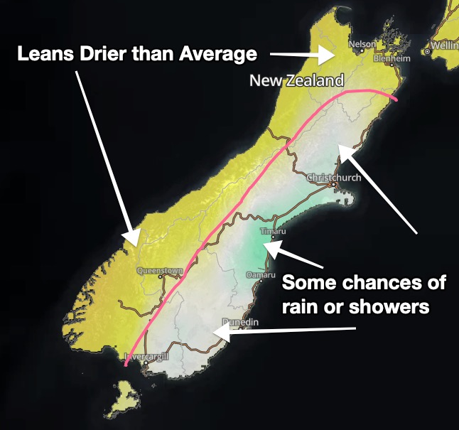
SUMMARY: February kicks off unsettled with storms in the Southern Ocean churning by. Remember the map above is rainfall compared to normal for February (historically what has been recorded over the decades). The colours don’t reflect totals. So the first five days of February look very wet on the West Coast – but then it dries out. Canterbury, which has significantly lower rainfall totals, has a chance of both spillover rain from the West Coast and a possible southerly on Feb 4 which could produce some helpful rain and showers. That may be enough to keep the month leaning average. But this is pretty borderline stuff, it wouldn’t take much for Canterbury to also be much drier than normal, especially North Canterbury. Nelson and Marlborough look drier than usual – and they’re normally pretty dry in February.
FEBRUARY TEMPERATURE TREND: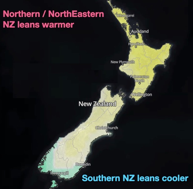
SUMMARY: Before we get too detailed we must point out the colours on the map above represent very little difference between north and south. For the most part the bulk of New Zealand leans warmer than average in February. With an uptick in high pressure over the country it does help even out the temperatures though. The Southern Ocean, being very active, is why Fiordland, coastal Southland and perhaps coastal Otago may at times dip a little cooler. But inland these same regions lean warmer than average.
– WeatherWatch.co.nz – An official IBM business partner
**Accuracy Disclaimer with Long Range Forecasts:
The IBM data/maps above show precipiptation will be above or below normal for a given month over a large area, this has a 60-65% forecast success rate. The state of the science and lack of open data in NZ simply doesn’t allow for more granularity or accuracy at this point.
Comments
Latest Video

Antarctic southerly for parts of NZ Fri & Sat
For the first time this year a southerly from off Antarctica is heading towards the South Island, followed by more…
Related Articles
Antarctic southerly for parts of NZ Fri & Sat
For the first time this year a southerly from off Antarctica is heading towards the South Island, followed by more…

Meteors – Your Eyewitness Reports!
WeatherWatch.co.nz receives meteor reports from all over New Zealand and the globe, 24/7/365. **CASUAL COMMENTS**If you’ve seen something in the…

Snow, rain showers & cold polar southerlies set to return
Friday will be a wintry day across NZ as the next cold front arrives, bringing snow to lower levels of…


Guest on 2/02/2020 3:45am
Wheres that coastal showers like in the past I live near the coast now no rain for 14 days
WW Forecast Team on 2/02/2020 6:38am
It’s been more settled lately, more anticyclones. Although depending where you live some will say it’s been quite windy still and everything else under the sun (ha! lol).
Que sera, sera
Aaron