
> From the WeatherWatch archives
Updated Friday PM — With an unsettled spring-like weather pattern affecting New Zealand at the moment many are asking just how conditions will be on New Year’s Eve. With a high departing and low coming in the weather will be going downhill for some – but as a result of the increasing winds it may make for warm, dry, weather for many more.
Across Saturday rain will fall on the West Coast in the South Island. A wet day with possible rain warnings is on the cards.
A low just south west of Fiordland will be helping fuel this rain – and the increasing nor’west winds ahead of it.
These winds will help make for a mild New Year’s Eve in the east (and gets hot on Sunday with highs into the 30s).
So yes, rain will be affecting some as this low brushes by to our south. Most holiday spots and party spots look dry or warm. Queenstown is possibly the highest candidate out of the large holiday spots for rain or showers on NYE with a 70% risk at this stage.
Can’t rule out a few spits or showers in Wellington, Christchurch and Dunedin but conditions look mostly dry. Winds may becoming strong around Wellington, Wairarapa, Marlborough and inland parts of Canterbury though.
If you want to check the % of rain for New Year’s Eve and New Year’s Day wherever you are in New Zealand try searching our 1500 forecasts here! We have most beaches, Kiwi communities and holiday spots. Remember – you can use the automatic “find my nearest location” function too.

InfoGraphic (Above) Saturday Dec 31, Sunday Jan 01
Saturday
Blue = Rain moves onto the West Coast of the South Island in the morning, heavy at times especially afternoon onwards.
Purple = Northwesterlies through Cook Strait becoming strong from afternoon, gusting to gale at times. Northwesterlies about inland Canterbury / Marlborough becoming brisk to strong in the evening.
Yellow = Temperatures getting into the mid 20’s for eastern parts of New Zealand in the afternoon.
Sunday
Blue = Heavy rain for North Westland easing from afternoon, pushing onto the lower North Island in the west during the evening.
Purple = Gale northwesterly winds through Cook Strait ease overnight. Brisk to strong northwesterly winds about the eastern South Island Banks Peninsula northwards ease in the evening.
Yellow = Temperatures getting into the late 20’s for eastern parts of New Zealand in the afternoon, perhaps even early 30’s for some eastern South Island areas.
 Rain map for close to midnight on NYE shows heavy rain on the West Coast but mainly dry elsewhere in the South Island – perhaps the risk of a spit or too east of the ranges. The North Island looks dry, but can’t rule out an isolated late shower or spit of rain in the lower North Island.
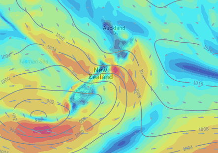
Wind map for 10pm NYE shows a low SW of Fiordland. Generally most of New Zealand isn’t too windy, but Cook Strait looks blustery which will affect the Marlborough Sounds and the lower North Island, including Wellington where winds may reach gale force on New Year’s Day.

Temperature map for around midnight on NYE shows many centres are mild in the mid to late teens.
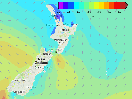
Swell map (as of Dec 29 for 10pm Dec 31) shows ideal conditions for boaties moored around Northland, Auckland, Coromandel Peninsula and much of Bay of Plenty, also Nelson and northern Taranaki – although remember winds are building to gale overnight around central New Zealand.
– WeatherWatch.co.nz with maps by Weathermap.co.nz
Latest Video

Cold weekend, frosts return with high pressure, then a low late next week
The subantarctic airflow spreads over NZ today/tonight and into Saturday, dropping temperatures nationwide. Snow flurries are possible today to lower…
Related Articles
Cold weekend, frosts return with high pressure, then a low late next week
The subantarctic airflow spreads over NZ today/tonight and into Saturday, dropping temperatures nationwide. Snow flurries are possible today to lower…

Wintry burst of weather: Snow, squally showers then sunshine & frosts
A polar change (another one!) arrives on Friday for the South Island and goes nationwide on Saturday, leaving NZ under…

Antarctic southerly for parts of NZ Fri & Sat
For the first time this year a southerly from off Antarctica is heading towards the South Island, followed by more…

