Fairly dry Saturday but a colder, windier, Sunday coming (+5 Maps, including updated Forecast Rainfall)
23/02/2019 2:57am

> From the WeatherWatch archives
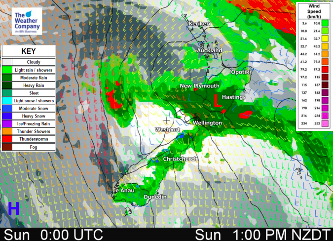
The main rain band is sliding out to east sea east of the upper North Island as of Saturday morning while a colder southerly works its way northwards. There is some patchy rain around the north east corner of the North Island, Gisborne/East Cape and parts of Hawke’s Bay for Saturday morning, this should mostly ease this morning. Later today some showers form around coastal Canterbury and will turn to patchy rain tonight/overnight.
A new large area of low pressure is forming this weekend to the east of NZ and will generate stronger southerlies on Sunday that will bring another burst of rain, more so to central and eastern parts of the country, but some downpours in the west too.
The main change on Sunday will be nationwide temperature drop with daytime highs well over 8 degrees below normal in some areas, like Canterbury along with a windier southerly change. The very north of the country may not be quite so impacted by the windier, cooler change but overnight lows in Auckland will be down also around 8 degrees on Sunday night compared to the past couple of nights.
Conditions ease on Monday in most regions but southerlies and showers will take until the end of the day to properly ease in the eastern North Island.


– WeatherWatch.co.nz
Comments
Latest Video

NI low pressure, SI polar change
Low pressure will move over the upper North Island this week, bringing hit and miss pockets of heavier rain into…
Related Articles
NI low pressure, SI polar change
Low pressure will move over the upper North Island this week, bringing hit and miss pockets of heavier rain into…

Rain & showers this weekend, colder change next week
Some places will warm up over the next day or so as a nor’wester out of Australia moves across NZ,…

Temperature changes for some regions ahead of heavy West Coast rain
A nor-wester is about to kick in and it’s coming from out of Australia, boosting temperatures in some regions going…


Guest on 24/02/2019 2:00pm
you said its ok if that cyclone doesn’t come here as there is this storm well guess what this storm gave 0.8 of a mil of rain and the tail of oma 32 mils….yeah right
Guest on 23/02/2019 2:41am
rain to the same places as far I can see from that southerlie