Enormous high will bring both dry weather and wet weather, cold and warm (+3 Maps)
5/06/2020 9:00pm

> From the WeatherWatch archives
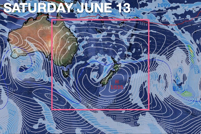
In the weather world we don’t say weather systems are ‘enormous’ very often – but this high pressure belt is. For a time next week it will roughly stretch 7000km across – to give some perspective Australia is almost 4000km from west to east and NZ is only 1600km from north to south.
The centre of this massive high pressure system will basically take all of next week to track from Adelaide to Sydney and over the Tasman Sea area, meaning New Zealand is in the cooler sou westerly flow for most of next week.
Put simply – next week leans drier than average in many places (with showers here and there) and cooler W to SW winds will be colder the further south you go.
Next weekend the high should cross NZ bringing lighter winds and a newly forming easterly flow for northerners.
But it’s the following week, 10 days from now, when this enormous high (and it’s enormous anticyclonic airflow) will start to depart east of NZ and this changes things.
As WeatherWatch.co.nz said in our recent June Climate Outlook, we expect rainfall levels to be closer to normal for northern NZ this month, that despite a drier than normal week on the way from tomorrow, Saturday, onwards.
We may see more evidence of this wetter weather as this high pressure system departs our shores pulling down northerlies from the sub-tropics into both islands and potentially sparking another rain maker for the north and west out in the Tasman Sea. It’s too far out to precisely lock in, but the maps below should help paint the picture in your head of the more likely scenario.
This is one big high with quite an interesting weather tale.

- WeatherWatch.co.nz for news, maps and video
- RuralWeather.co.nz – The most accurate local weather data on earth for New Zealand
Comments
Latest Video

Antarctic southerly for parts of NZ Fri & Sat
For the first time this year a southerly from off Antarctica is heading towards the South Island, followed by more…
Related Articles
Antarctic southerly for parts of NZ Fri & Sat
For the first time this year a southerly from off Antarctica is heading towards the South Island, followed by more…

Meteors – Your Eyewitness Reports!
WeatherWatch.co.nz receives meteor reports from all over New Zealand and the globe, 24/7/365. **CASUAL COMMENTS**If you’ve seen something in the…

Snow, rain showers & cold polar southerlies set to return
Friday will be a wintry day across NZ as the next cold front arrives, bringing snow to lower levels of…


Christopher Randal on 6/06/2020 4:18am
That High contracts a lot over 9 days doesn’t it?
From what I remember of CPL meteorology highs can block lows, but can that low (985mb) out to block the high?
WW Forecast Team on 7/06/2020 8:48pm
Hi Christopher… highs tend to behave like human lungs, they expand and contract a lot as they move along. This also changes their shape which alters wind flows. Highs block lows because as a low tries to move into a high the low gets torn apart most often. As the high moves in around a low it basically tears the top of the low off at high altitudes and it ‘squashes it’. So normally highs win out (not always, but usually). It’s in the squash zone between the two which can often be windiest too. (neither high nor low!).
Cheers
Phil D
Peter Thomas Langer on 5/06/2020 3:34am
its ok as long as we get 100 mils a month and we are nearly there already