
> From the WeatherWatch archives
Two tropical cyclones have formed in the past 24 hours north of New Zealand reports WeatherWatch.co.nz.
Tropical Cyclone Tomas, currently a Category 2 cyclone, is situated north east of Fiji and is likely to track south west towards the main island. Tomas isn’t expected to make a direct hit on the main island of Viti Levu but could still bring strong winds and heavy rain to Suva in the coming days.
Tomas currently has sustained winds of 90km/h but that is likely to increase to 140km/h in the coming 24 hours says the Fiji Meteorological S
Tropical Cyclone Tomas is expected to hit the north eastern part of Vanua Levu (the main island to the north east of Fiji) with huge seas, flooding rains and damaging gales.
Tomas is expected to track south west, then south and then south east taking it away from New Zealand. It’s possible Tomas could produce slightly bigger seas for the North Island’s east coast from Wednesday next week.
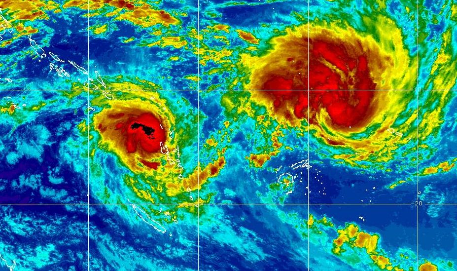
Tropical Cyclone Ului (left) swirls north of New Caledonia while Tropical Cyclone Tomas (larger red blob top right) heads towards the north eastern islands of Fiji. Image / MTSAT GOES
Meanwhile another Category 2 cyclone has formed, Tropical Cyclone Ului has developed near New Caledonia. WeatherWatch.co.nz says out of the two storm Ului has the potential to become the most powerful and could pose a threat to a number of countries including Australia and possibly New Zealand.
At this stage long range computer models show Ului will travel very slowly westwards towards Australia.
Head weather analyst Philip Duncan says that while there’s only a very slight chance Ului may affect New Zealand any storm that moves into the Coral Sea is always worth watching. “It’s in an area where it can grow into a monster category 5 storm and the only thing protecting New Zealand and this storm will be a high pressure system…so if the high weakens, the threat to New Zealand increases”.
Mr Duncan says all long range forecasts show that the high will hold strong fort he next week. “This will be something to watch later next week, if not for New Zealand then certainly for north eastern Australia”.
The cyclone could cause major damage to the Great Barrier Reef and bring huge seas right along Australia’s east coast.
Comments
Latest Video

Some polar airflows but more high pressure to affect NZ’s weather
Showers are in the forecast over the next several days, we track where and when they occur – but there…
Related Articles

ClimateWatch: JULY outlook & what El Niño means for NZ
El Niño is officially here and still getting stronger in the months ahead, but it’s harder to notice its effects…

ClimateWatch: JUNE outlook as El Niño continues to build
June has kicked off in NEUTRAL again as far as El Niño is concerned, but it is expected to form…

ClimateWatch: May outlook & El Niño discussion
Everyone is talking about El Niño so in this month’s update we discuss when it may be forming and what…


Guest on 14/03/2010 12:13am
Ului has intensified last night into a Cat.4 storm and is approx. 266 kilometers (162.4Deg E) from entering Australian waters (that is 160 deg East)
Latest update is
TROPICAL CYCLONE ULUI CENTRE 945HPA CATEGORY 4 LOCATED NEAR 13.0 SOUTH 162.4
EAST AT 131800 UTC.
POSITION FAIR.
REPEAT POSITION 13.0S 162.4E AT 131800 UTC.
CYCLONE MOVING WEST AT 06 KNOTS.
EXPECT SUSTAINED WINDS OF 100 KNOTS CLOSE TO THE CENTRE INCREASING TO 115 KNOTS
IN THE NEXT 18 TO 24 HOURS
Guest on 13/03/2010 11:04am
Is Tropical Cyclone Ului heading towards Noumea / Lifou, New Caledonia??
WW Forecast Team on 13/03/2010 6:35pm
HI there,
At this stage it looks like it’s going to move west out into the Coral Sea… hopefully sparing New Caledonia. Check back for updates as the storm has only just developed.
Cheers
WeatherWatch