Damaging winds possible Saturday evening for top of NZ (+Map & photos)
20/05/2016 10:57pm

> From the WeatherWatch archives
New Zealand is under a very large area of low pressure, which has now become a couple of low pressure systems, with one centre moving up the western coastline of both islands, and the other hovering off the Canterbury and Otago coastlines.
The main feature with both of these lows is gale to hurricane force winds (over 120km/h possible). In fact some models show gusts around 140 to 150km/h out at sea both west of Northland and Auckland and east of Otago later today, but the bulk of the wind is in the Tasman.
The centre of the northern low is going to cross over Auckland city tonight and to the left hand side of the low, or western side, the wall of gale to hurricane force winds will push across Northland and cross/brush the Auckland region. However it’s important to note that to the south east the winds aren’t so strong – we often see a fine line between rain and sun with fronts crossing New Zealand, with this low there may be a fairly fine line between damaging wind gusts and winds that’s aren’t too extreme.
As we head into Saturday afternoon scattered thunderstorms will affect the western coastline here and there with very sudden and heavy downpours too.
The worst of the winds will likely be this evening, then gradually easing back after midnight.
The cooler air has already produced snow on Mt Ruapehu finally too!
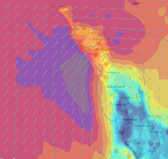 The mid evening wind map shows hurricane/severe gale winds to the west (in purple/grey). The winds are SW but the movement of this area of gales is NE so it will be crossing Northland and crossing/brushing Auckland. Note the fine line between damaging winds and the lighter winds across Waikato (pale/dark blue) / Weathermap
“Snow to excite the ski bunnies. On Ruapehu this morning” photo and credit by Ben Haarmann on Twitter @waihisurfie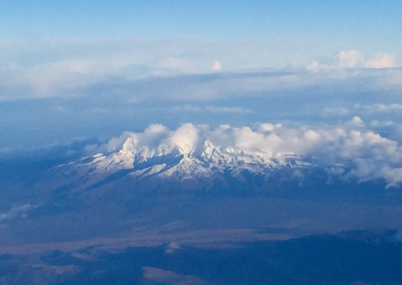
Meanwhile @matthewjpg on Twitter sent in this photo of an uprooted tree. The town also had powercuts last night as the thunderstorms crossed over: “The result of last nights storm in Putaruru”
– WeatherWatch.co.nz
Latest Video

Cold weekend, frosts return with high pressure, then a low late next week
The subantarctic airflow spreads over NZ today/tonight and into Saturday, dropping temperatures nationwide. Snow flurries are possible today to lower…
Related Articles
Cold weekend, frosts return with high pressure, then a low late next week
The subantarctic airflow spreads over NZ today/tonight and into Saturday, dropping temperatures nationwide. Snow flurries are possible today to lower…

Wintry burst of weather: Snow, squally showers then sunshine & frosts
A polar change (another one!) arrives on Friday for the South Island and goes nationwide on Saturday, leaving NZ under…

Antarctic southerly for parts of NZ Fri & Sat
For the first time this year a southerly from off Antarctica is heading towards the South Island, followed by more…

