
> From the WeatherWatch archives
Severe tropical cyclone Yasi is quickly gaining strength as it roars towards the Queensland coast, ahead of major evacuations that involve entire suburbs.
WeatherWatch.co.nz says the cyclone may even be stronger than Wilma, which peaked as a Category 4 cyclone shortly before weakening as it moved over New Zealand waters.
But unlike Wilma, Yasi is gaining power and now covers an area up to 2500kms wide.
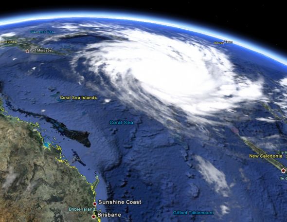
Severe Tropical Cyclone Yasi – just 1500kms east of Cairns / Google Earth
The cyclone is predicted to hit just south of Cairns – potentially within just 80kms of the city centre. The greater city area is home to about 160,000 people.
Yasi comes just after Cyclone Anthony, a weak category 1 cyclone, which hit early Monday morning and dumped up to 266mm in some places within 24 hours.
Last week WeatherWatch.co.nz was the first forecaster in Australasia to warn of Cyclone Yasi and today the weather news authority says it has the potential to be devastating to the region.
ABC is reporting that Queensland Premier Anna Bligh says the cyclone bearing down on the Queensland coast has the potential to be the biggest the state has ever seen.
“This is an event we have to take seriously. I know cyclones can at the last minute turn off the coast, and I certainly hope this one does.
“But the bureau advises me in the most serious terms, that all of the modelling right now says this is going to cross our coast.”
Yasi is expected to have winds of up to 280km/h when it makes landfall, as early as 38 hours away (early hours of Thursday morning NZT).
– WeatherWatch.co.nz
WeatherWatch.co.nz will have extensive coverage of Yasi over the coming two days
Comments
Latest Video

Cold weekend, frosts return with high pressure, then a low late next week
The subantarctic airflow spreads over NZ today/tonight and into Saturday, dropping temperatures nationwide. Snow flurries are possible today to lower…
Related Articles

Snow, rain showers & cold polar southerlies set to return
Friday will be a wintry day across NZ as the next cold front arrives, bringing snow to lower levels of…

Polar airflows set to bring cold weekend to NZ
Nor-west winds will be building over parts of NZ going into Thursday with rain on the West Coast becoming heavy…

ClimateWatch: JULY outlook & what El Niño means for NZ
El Niño is officially here and still getting stronger in the months ahead, but it’s harder to notice its effects…


Nicola on 1/02/2011 3:33am
Hi, what are the chances that Yasi could turn south and hit Brisbane? As it’s currently tracking, is Brisbane likely to be affected?
Cheers
Judi on 1/02/2011 1:29am
Yasi looks terrifying and I feel for the Australians after what they have already suffered. Following your earlier comment I took your advice and have made you the only weather commentator to pay attention to. You were first to recognise Yasi – congratulations. I hear tell that there are another couple of would-be cyclones about to grace us with their presence shortly. Do you have track of these two that are hovering around the Pacific area at the moment, and if so, what forecast do you predict for their ability to create another weekend of havoc? Great site – I recommend you to all that watch the weather.
Regards,
Robyn on 31/01/2011 11:20pm
Hi im just wondering if u know what effect cyclone yasi will have on cairns as i have family there do you see cairns residents having to evactuate ? Thankyou awesome website love it!
WW Forecast Team on 1/02/2011 12:51am
Hi Robyn
The most destructive winds and rain will be right near the centre, which will make landfall (at this stage) within 90kms of Cairns. This could be quite devastating for people who live just south of Cairns on the coastline.
The order is for people in low lying coastal areas to head further inland today or early tomorrow.
– WW
Nicole on 31/01/2011 10:52pm
Any Idea where Yasi will head once it makes landfall in Queensland?
WW Forecast Team on 1/02/2011 12:52am
It actually looks as though it will continue tracking WSW into the interior and reach Alice Springs. With the amount of rain the Desert has had this year it may be covered in grass now! Yasi will weaken very quickly once it makes landfall.
– WW