Cyclone Trevor’s remnants may spark new rainmaker for dry parts of NZ early April (+3 Maps)
24/03/2019 10:18pm

> From the WeatherWatch archives
What is now Ex-Cyclone Trevor continues to bring rain to inland parts of Queensland and this week the rainmaker will drift east and join forces with a cold front in the Tasman Sea on Friday, sparking a new rain band and possibly a new low pressure system in the New Zealand area.
It’s important because it may bring rain relief to parched parts of the North Island in the first few days of April.
While there is a big rain maker this week on the West Coast with potentially over 400mm of rain coming it’s likely to fall apart quite a bit as it tracks into the North Island later on Wednesday and Thursday and runs into high pressure over northern NZ. It’s unlikely to deliver enough rain to help seriously reverse the big dry – although some rain will be very welcome.
But this secondary burst of rain connected with Trevor early next week may perhaps bring better chances of North Island rain.
At this stage it is certainly not locked in – but just giving a heads up that April 1 and April 2 may see rain falling over dry parts of the North Island. We’ll keep you updated in the week to come.
VIDEO: A stormier Autumn pattern arrives this week, ex-cyclone Trevor may bring rain next week
RAINFALL ACCUMULATION BETWEEN NOW AND APRIL 3 (TOP via ECMWF, bottom via GFS)

RAINFALL ACCUMULATION MAP – EXTRA LONG RANGE – TO APRIL 9 (Via GFS)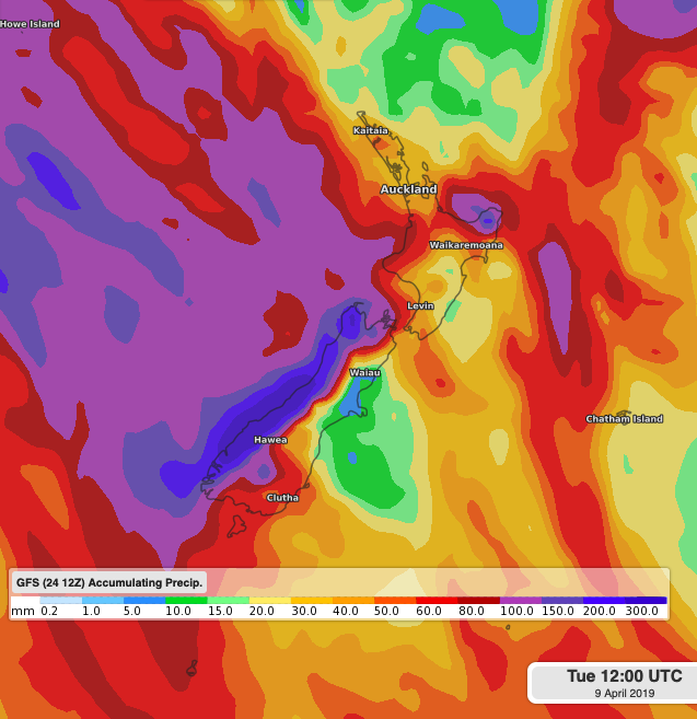
WeatherWatch.co.nz
Latest Video

Westerlies continue, sub-tropical for some
West to north-west winds blow through the South Island and lower North Island today bring heavy West Coast rain and…
Related Articles
Westerlies continue, sub-tropical for some
West to north-west winds blow through the South Island and lower North Island today bring heavy West Coast rain and…

Westerly change this week, unsettled but large dry areas
Westerlies kick back in again this week which will bring a break to those in the east as far as…

Matariki, the long weekend + the outlook for next week
Wet weather and cloud continues along the eastern side of the country with the heaviest rain now moving into northern…

