
> From the WeatherWatch archives
Extensive Coverage — Tropical Cyclone Jasmine has this afternoon weakened a little from a Category 4 cyclone to a Category 3 storm and is now tracking directly towards New Zealand – but don’t panic, it’s still not expected to hit us. We have several maps and the latest tracking and forecasts for Cyclone Jasmine as the outer bands move within 1000kms of northern New Zealand.
As of 5pm NZT the Fiji Met Service says Jasmine’s current air pressure was 955hPa and the cyclone is almost tracking due south – moving 18km/h in a SSE direction.
The difference in category status is minimal – with Jasmine a very strong Cat 3 storm, bordering on Cat 4, however the cyclone is slowly weakening now as it heads over cooler waters – and starts to be pulled apart by an incoming high (currently moving in from the Tasman Sea).
WeatherWatch.co.nz maintains that Jasmine will come within 800kms north of the country however it will be weakening as it heads south – and as the incoming high tears it apart its means the storm will have less impact further afield.
Large swells from Jasmine may not reach New Zealand but WeatherWatch.co.nz advises swimmers especially to be vigilant of hidden rips along northern coastlines from Cape Reinga to East Cape. Offshore cyclones frequently create dangerous rips in New Zealand even though the weather onland can be sunny and settled.
In February last year, on the same day as the Christchurch earthquake, cyclone Atu passed well east of New Zealand and while the weather was sunny and settled over the North Island the offshore storm dragged several swimmers out to sea in Wairarapa. All were luckily rescued from the dangerous rip caused by Atu.
As for the future of Jasmine, less favourable conditions further south of the tropics means she will eventually fall apart – most likely early to mid next week roughly 2000kms to our north east.
However tropical cyclones are well known for being unpredictable, so WeatherWatch.co.nz will continue to monitor Jasmine incase larger swells do reach our shores.
All models agree that Jasmine will not come close enough to bring severe weather conditions to mainland New Zealand but it could bring a period of rain and gales to Raoul Island, just under 1000kms north east of the North Island, home to a handful of DoC workers.

Latest future track map by Fiji Met Service
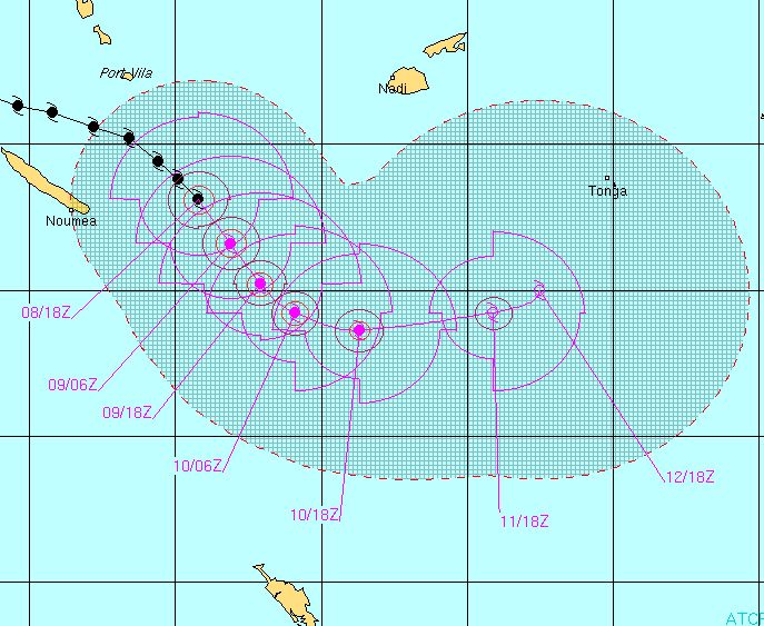
Joint Typhoon Warning Centre (JTWC) – predicted track as of Thursday afternoon NZT

Current sea surface temperatures – X marks the spot where Jasmine currently lies, but cooler conditions closer to NZ (orange) will see her weaken further – coupled with a high moving in from the Tasman, which should finish the job of weakening the cyclone.

The swell map as of Saturday shows some large seas just north of Cape Reinga, but for the most part conditions won’t be too severe around our beaches. However a 1 metre northerly swell is something swimmers should be aware of, as offshore storms can increase the rip dangers significantly, even if the weather at the beach is settled and sunny.
The above two maps are provided by MetOcean – to see all our interactive maps, including the latest animated maps which clearly show Jasmine’s eye, please click here to go to our maps page.
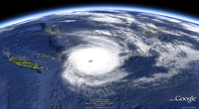
Above – Cyclone Jasmine as of 4pm NZT Thursday – east of New Caledonia, south east of Vanuatu and south west of Fiji… Jasmine is currently tracking SSE at 18km/h and will eventually turn more easterly again, sparing NZ from a hit.
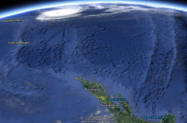
Below – Looking north from New Zealand’s upper North Island to Jasmine, currently about 1300kms north of NZ Sat maps courtesy of Google Earth.
– WeatherWatch.co.nz Exclusive
Latest Video

Wintry weather coming: Snow, rain, wind & sunshine
A cold front is moving into NZ from Friday to Sunday with low pressure developing west of NZ and then…
Related Articles

Polar airflow + northern low = pockets of heavy rain & snow
A colder change is coming – and so too is a large low which will develop and grow over northern…
Wintry weather coming: Snow, rain, wind & sunshine
A cold front is moving into NZ from Friday to Sunday with low pressure developing west of NZ and then…

ClimateWatch: JULY outlook & what El Niño means for NZ
El Niño is officially here and still getting stronger in the months ahead, but it’s harder to notice its effects…

