Conditions slowly ease in Fiji as Evan departs for NZ (+maps)
17/12/2012 7:00pm

> From the WeatherWatch archives
It will be another windy and wet day across Fiji however severe tropical cyclone Evan is now starting his gradual move to the south towards New Zealand.
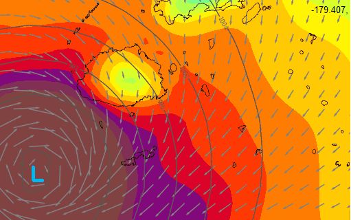 Cyclone Evan as of 7am (source Fiji Met)
- Air Pressure: 945hPa
- Category: 4
- Direction: Moving SW at 17km/h
- Sustained Winds: 165km/h
- Gusts: Over 230km/h
- Location: SW of Nadi
(Image / Brown/Purple indicates hurricane force winds, red and orange gales, yellow moderate winds. Image / Weathermap.co.nz)
WeatherWatch.co.nz says the tropical storm has weakened a bit overnight as it passed by Fiji and will very slowly weaken over the next day or two.
More heavy rain is predicted today as hurricane force winds ease but only back to gale force, although gales are far less damaging. Winds and rain will ease for most places later today or overnight.
The Fiji Met service now has flood warnings as more bursts of heavy rain move in today.
As of 7am flood warnings were in force with the Rewa River which was just 30cms below critical levels and still rising.
Other rivers have already exceeded critical levels. The Navua is already a metre over that level while the Wainibuka is a staggering 7.2 metres above critical. The next high tide is around 11am.
At 4pm today Evan is expected to lie 290kms south oif Nadi.

WeatherWatch.co.nz says satellite imagery confirms the cyclone has weakened, due to the island of Fiji interrupting the structure of the cyclone as Evan passed by the large, hilly, island, but it still remains a very dangerous Category 4 tropical cyclone.
Evan arriving this weekend in New Zealand
WeatherWatch.co.nz head weather analyst Philip Duncan says Evan has no where to really go but northern New Zealand now. “Evan is just now leaving Fiji and is on a direct path for the upper North Island. He will pick up speed tomorrow and start to affect our weather as early as Saturday morning with increasing clouds, some rain in the north and building east to south east winds”.
“Some people have asked me if Evan arrives this weekend or Christmas Day – well it’s a bit of both as the remnants of the storm are expected to arrive this weekend and linger until Christmas Day as the storm slowly unravels over the top half of the North Island”
Mr Duncan says a large high over the South Island will trap the low, starve it of more fuel and basically tear it apart. “We think this will happen over the upper North Island meaning conditions will be easing – but it still may make for a cloudy, wet, humid few days”.
“Saturday to Monday look wettest and windiest with conditions easing on Monday. By Christmas Day it looks as though the final scraps of Evan will cross over the eastern North Island hopefully with enough energy for an early morning Christmas present for farmers desperately in need of rain – then it should clear during the day for most places”.
The South Island and lower North Island are expected to be only slightly affected by Evan’s remnants with the South Island having brilliant Christmas Day weather for most main centres under that high pressure zone.
The final days of Evan over New Zealand
SATURDAY.jpg)
SUNDAY.jpg)
CHRISTMAS EVE – MONDAY.jpg)
CHRISTMAS DAY – TUESDAY.jpg)
– Credit for these maps: www.WeatherMap.co.nz
– WeatherWatch.co.nz
Comments
Latest Video

Cold weekend, frosts return with high pressure, then a low late next week
The subantarctic airflow spreads over NZ today/tonight and into Saturday, dropping temperatures nationwide. Snow flurries are possible today to lower…
Related Articles
Cold weekend, frosts return with high pressure, then a low late next week
The subantarctic airflow spreads over NZ today/tonight and into Saturday, dropping temperatures nationwide. Snow flurries are possible today to lower…

Wintry burst of weather: Snow, squally showers then sunshine & frosts
A polar change (another one!) arrives on Friday for the South Island and goes nationwide on Saturday, leaving NZ under…

Antarctic southerly for parts of NZ Fri & Sat
For the first time this year a southerly from off Antarctica is heading towards the South Island, followed by more…


Jonesy on 17/12/2012 11:48pm
As a resident of West Auckland, do you think Kiwis should be worried about a Tornado or funnel cloud with this front?
hitadmin on 18/12/2012 12:26am
Hi Jonesy,
While tropical storms can produce tornadoes that currently isn’t in our forecast. It’s a different system from the ones that have produced tornadoes in Auckland over the past two years – and it looks as though the centre may be out to the east of Northland rather than in the Tasman (although one model is still saying it could end up in the Tasman). The humid weather left behind is more likely to produce some thunderstorms inland after Christmas – that could be something to watch. As it gets closer we’ll be able to significantly fine tune our forecasts.
Cheers
Phil
Guestrobert on 17/12/2012 8:38pm
ohh i love storms and murphys law we just get the left overs of them and that hot muggy gloomy day i hate the muggy weather any sign of it growing again i no weid i like storms thanks for keeping us in formed hope you have a great xmas robert oconnell teatatu sth auckland
westcoast on 17/12/2012 7:31pm
still lots of variation in the models to come yet, I would not take it as concrete yet that it will go down the eastern side of the NI
it could instead go down the western side of the NI or stall just to the north of NZ and then fizzle out there
hitadmin on 17/12/2012 7:58pm
Yep, we’ve been saying that all along that tropical storms have a mind of their own and while confidence is now high that Evan will reach NZ confidence remains fairly low about exactly what happens. ECMWF still have it fading out in the Tasman Sea rather than the east coast. Confidence is only about 30% for the Christmas Day east coast track, but it’s the highest confidence we have at the moment. Either way, the upper NI looks a bit gloomy this coming weekend!
Cheers
Phil
Dave on 17/12/2012 7:30pm
A great service you are providing Phil. If we relied on our Metservice friends we would be getting none of this coverage.
Keep up the great work & I wish you all the best for Xmas
Cheers
Dave
hitadmin on 17/12/2012 8:03pm
Thank you Dave, very much appreciated. Our entire website exists for storms like this and has done so since day one. We felt a need to step up in this area several years ago and haven’t looked back.
Merry Christmas to you too!
Phil and the team