Colder change coming on Friday, spreads nationwide. A December frost possible for some in the S.I. (+Maps)
9/12/2020 6:58pm

> From the WeatherWatch archives
It’s still humid in northern NZ but a cooler change is coming in for Friday night – nationwide.
The windier west to south west change will be most felt in the lower South Island, with a cooler than average change spreading in behind it across Friday and into Saturday.
Friday will see the South Island lean cooler than average in some regions, like Southland, some parts of Otago and Canterbury and the more populated parts of the West Coast.
The north and north east of the North Island continues with the warmer than average weather set up for the rest of Friday.
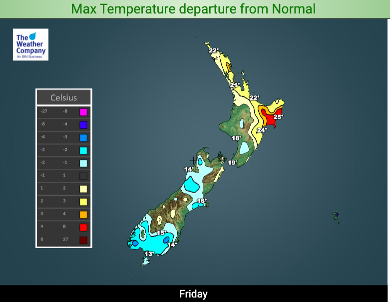
However by Friday night temperatures drop in many places nationwide.
All of New Zealand will either be below average, or about average, over Friday night. No one will be warmer than average for the first time this week.
In the South Island, inland and through the high country of Canterbury, there is even the chance of a frost tonight.
The Below Zero temperature maps at WeatherWatch show this frost risk (highlighted in purple) www.weatherwatch.co.nz/maps-radars/temperature/below-zero.
Any frosts will be very limited to inland areas through the mountains. No frost risks exist in more populated places.

Don’t forget to double check! Use the exclusive Frost Forecaster at www.RuralWeather.co.nz for more info!
Latest Video

More eastern rain, but a drier long weekend coming
Rain continues today along the eastern South Island and lower North Island, coming in from the east with heavy falls….
Related Articles
More eastern rain, but a drier long weekend coming
Rain continues today along the eastern South Island and lower North Island, coming in from the east with heavy falls….

More heavy rain, snow – but large dry areas, especially as we go into the long weekend
Heavy rain will continue for parts of Canterbury and Marlborough over the next day or two and it will gradually…

Large low brings rain, downpours & some snow – gets colder as the week progresses
Low pressure will cross the upper North Island in the days ahead and that set-up actually pushes more heavy rain…

