Cold snap arrives, but only half of NZ below average temperature-wise (+5 maps)
30/07/2019 11:13pm

> From the WeatherWatch archives
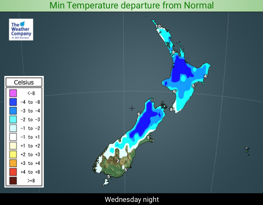
We may be getting a wintry snap but it’s only resetting temperatures back to normal for half of the country, with the other half dipping slightly below normal. It’s a bit of a surprising reminder that July has been much warmer than average by day.
Over the past week some places were several degrees above normal, so even a temperature drop of several degrees today only brings the mercury back to where it should be. As the sun sets tonight temperatures will drop further and the cold change will peak, but even though still around 30% of the nation will have normal temperatures.
In fact it’s such a short lived cold event that by Thursday afternoon 30% of the South Island will be warmer than normal for August 1st, and most main centres in the North Island will have average temperatures, despite the daytime highs being down several degrees.
Another surge of weather comes in on Friday and through the weekend but it will have more of a westerly lean to it – so while windy and wet in some areas, the temperatures won’t be extreme or below normal for most. Windy weather looks to be the main feature of the weather this weekend.


3 DAY RAINFALL:

– WeatherWatch.co.nz
Latest Video

Cold weekend, frosts return with high pressure, then a low late next week
The subantarctic airflow spreads over NZ today/tonight and into Saturday, dropping temperatures nationwide. Snow flurries are possible today to lower…
Related Articles
Cold weekend, frosts return with high pressure, then a low late next week
The subantarctic airflow spreads over NZ today/tonight and into Saturday, dropping temperatures nationwide. Snow flurries are possible today to lower…

Wintry burst of weather: Snow, squally showers then sunshine & frosts
A polar change (another one!) arrives on Friday for the South Island and goes nationwide on Saturday, leaving NZ under…

Antarctic southerly for parts of NZ Fri & Sat
For the first time this year a southerly from off Antarctica is heading towards the South Island, followed by more…

