Cliff Collapse at Cape Kidnappers that injured 2 now being investigated by GeoNet
4/02/2019 8:20pm

> From the WeatherWatch archives
Landslides are one of the geohazards that GeoNet monitors and last week our landslide team responded to a cliff collapse event at Cape Kidnappers that injured two people. The cliff collapse occurred on Wednesday 23 January in the early afternoon on the coastal cliffs between Clifton and Cape Kidnappers on the Hawke’s Bay coastline.
The beach along this coastline is used for access to the Cape Kidnappers Gannet Colony by a tourist operation and by day walkers. At the time of the collapse a local tour group was nearby, and two people who were on the beach at the time were injured.
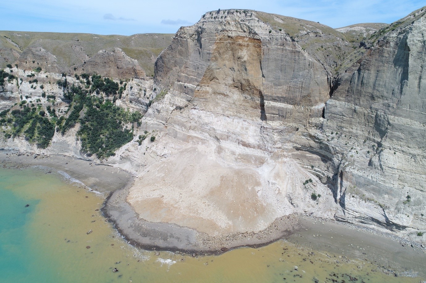
Cliff collapse at Cape Kidnappers – 23 January 2019 – GeoNet
GeoNet’s landslide team was deployed to the area last Friday to collect data from the site. Landslides occur frequently in New Zealand. However, some pose a bigger threat to human safety than others. Just as we monitor earthquakes, tsunami and volcanic activity, we also monitor landslides to gather data about how the New Zealand landscape is changing, and to inform decisions about keeping the public safe.
“Our team responded to this event to gather data to use in research and for input into future work to evaluate life safety risks so they can be better managedâ€, says GNS Science engineering geologist Sally Dellow.
“Cliff collapse events in this area are relatively common. Smaller events occur every year. Cliff collapse events of a size similar to the 23 January event probably occur on this stretch of coastline every two to five yearsâ€.
The purpose of these missions is to ensure that appropriate information is available to maximise public safety. It’s also to collect reliable landslide data that helps us understand the frequency and magnitude of these events and how vulnerable people are to them.
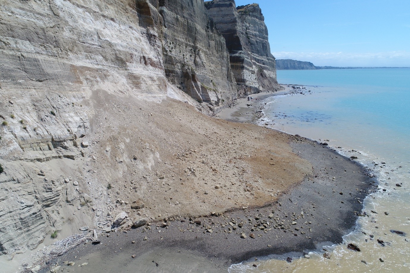
Close-up of cliff collapse at Cape Kidnappers – 23 January 2019 – GeoNet
The team has put together a ‘change model’ using LiDAR (light detection and ranging) data from 2003 and 2011 to show the impact and volume of previous collapses along part of the cliff face.
GeoNet uses LiDAR to see how much of the land has moved and they can calculate volumes of movement from this data. Unfortunately, the LiDAR data in the below graphic does not extend to the site of this recent cliff collapse but shows land movement along the same stretch of coastline.
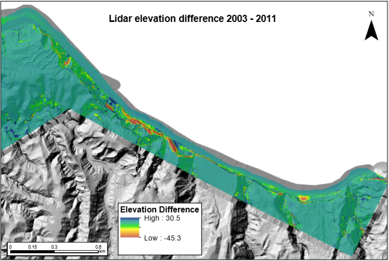
LiDAR elevation difference – GeoNet. Red colours are erosion/loss (source) and blue colours are deposition/gain (what remains of the deposits – most is washed away by the sea).
The beach route to the Gannet Colony is currently closed to the public.
Hastings District Council and their geotechnical consultants are currently assessing the risk and they will advise on how the risk will be managed going forward.
This is an ongoing issue and we will continue to provide support to the council. We are still processing data and this will be made available in due course.
To view previous landslide reports, click here.
– By Sally Dellow, GNS Science Engineering Geologist.
Latest Video

Cold weekend, frosts return with high pressure, then a low late next week
The subantarctic airflow spreads over NZ today/tonight and into Saturday, dropping temperatures nationwide. Snow flurries are possible today to lower…
Related Articles
Cold weekend, frosts return with high pressure, then a low late next week
The subantarctic airflow spreads over NZ today/tonight and into Saturday, dropping temperatures nationwide. Snow flurries are possible today to lower…

Wintry burst of weather: Snow, squally showers then sunshine & frosts
A polar change (another one!) arrives on Friday for the South Island and goes nationwide on Saturday, leaving NZ under…

Antarctic southerly for parts of NZ Fri & Sat
For the first time this year a southerly from off Antarctica is heading towards the South Island, followed by more…

