Christmas Day: We track the developing downpours + warm & cool spots (+3 Maps)
22/12/2019 10:20pm

> From the WeatherWatch archives
UPDATED MONDAY — We have an even more detailed update, taking a look at rain maps for 6am, 12noon and 6pm on December 25th.
Generally speaking high pressure is nearby and showers will expand across New Zealand thanks to daytime heating. It means while some areas may have a high risk of a shower or downpour, they will be a bit hit and miss.
Temperatures are well down in some southern and eastern regions – of both islands but especially the south eastern South Island.
WET WEATHER:
The maps below paint a picture of light showers in the North Island in the morning expanding inland with daytime heating to create afternoon downpours (and possibly some isolated inland thunderstorms). Sea breezes / light winds will then drift these downpours. Each day the maps we’ve looked at have shifted the downpours around but regions like WAIKATO, inland BOP, CENTRAL PLATEAU and the HAWKE’S BAY RANGES areas appear to be highest risk areas for afternoon downpours. There may also be some isolated thunderstorms.
In the South Island showers are likely to hug Dunedin for a time but dry elsewhere, then afternoon downpours develop along the ranges – easing in the evening.
TEMPERATURES:
Many places will have fairly pleasant temperatures but definitely some candidates are looking to have a cool day.
It’s still looking a little cold in coastal Southland and some parts of Otago with highs of just 11 to 16 degrees for many places.
Further north and along the eastern side of both islands a cooler breeze will blow. Canterbury has highs from just 14 in some coastal areas up to around 20 well inland. Christchurch has a high of only around 15 to 17 degrees.
Some parts of Wairarapa, Wellington and Hawke’s Bay may not climb out of the mid to late teens.
Inland you may climb over 20 degrees but cloud build ups further inland may limit how hot it gets. Northern NZ (Waikato northwards) looks to be warmest with highs in the mid 20s possible and could “feel like” over 30 degrees in some sunny, sheltered, inland areas.
WIND:
Not much in the way of wind on Christmas Day with variable breezes natinowide.
*THIS IS OUR FINAL UPDATE FOR CHRISTMAS DAY – Please refer to your local 10 day and hourly forecasts for more details over the next day or two ahead.
6AM DEC 25: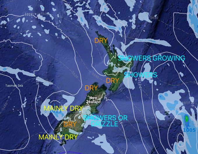
12NOON DEC 25
6PM DEC 25
**Please refer to your local 10 day and hourly forecasts to fine tune the above, we have thousands of NZ locations**
– WeatherWatch.co.nz
Comments
Latest Video

Polar airflows set to bring cold weekend to NZ
Nor-west winds will be building over parts of NZ going into Thursday with rain on the West Coast becoming heavy…
Related Articles

NZ: Cold & windy, then calm & frosty
Downpours, some squally with the chance of thunderstorms and even small tornadoes are possible for parts of NZ over Friday…

WeatherWatch App launches real-time local lightning tracker
A bolt out of the blue! WeatherWatch has launched a live, real-time lightning tracker, enabling Kiwis to gain access to data provided by the…

Wind, rain, showers & a noticeable temperature drop for all
It will be a colder weekend right across NZ as a sub-Antarctic southerly blows through, bringing frosts, snow flurries and…


Zelda on 22/12/2019 10:06am
Great getting SE wind flow, cooler.
MERRY CHRISTMAS to all
What is with this sign “Unable to create scaled Thumbnail image” and blank image holder “Fluctus”?
WW Forecast Team on 22/12/2019 10:12am
Merry Christmas to you too Zelda!
I’m curious about those issues also. Will notifiy Phil!
Cheers
Aaron
Zelda on 23/12/2019 2:27am
Thanks Aaron!
Site looks better today with the fix!