
> From the WeatherWatch archives
UPDATED
Severe tropical cyclone Tomas is tonight starting to move away from the two main Fijian islands. This afternoon Tomas made a direct hit over the Southern Lau Group of islands, south east of Vanua Levu Island. The area is made up of dozens of large volcanic islands home to about 11,000 people.
Tomas remained a Category 4 cyclone with sustained winds of 175km/h however is expected to ease to 150km/h during Wednesday. Tonight gusts are still estimated to be reaching up to 250km/h.
WeatherWatch.co.nz says the eye of the cyclone is now beginning to clear the dozens of islands and should head out over the open waters of the Pacific Ocean overnight tonight.
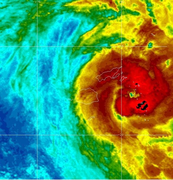
Tropical Cyclone Tomas making a direct hit over the Southern Lau Group around noon Wednesday. The two main islands of Fiji, outlined in white, can be seen in the centre of the image well west of the storm’s eye. Image / GOES, NOAA
Head weather analyst Philip Duncan says the south east region is in for at least 6 to 10 more hours of severe weather.
Mr Duncan says it’s possible the storm may bring slightly larger seas to New Zealand’s east coast in the next few days, particularly around East Cape, Gisborne and Hawkes Bay.
Meanwhile Tropical Cyclone Ului has stalled today but and even weakened a little. The Category 4 cyclone is moving at just 5km/h, slower than walking speed. This movement may mean it won’t change in strength for another day or two however as of Tuesday evening the eye of the cyclone was becoming better defined – indicating better organisation.
Sustained winds are around 175km/h at present.
Ului – pronounced “you-loo-ee” – is posing no threat to land at this stage. The fact that the storm has stalled is causing some confusion as to where it will eventually end up tracking.
WeatherWatch.co.nz is monitoring a number of different computer models and during Tuesday there was increasing confidence that the tropical cyclone will slam into Australia’s north east coastline this weekend. If this happens it will most likely spare New Zealand of the storm.
However latest weather data available to WeatherWatch.co.nz indicates a shift to nor’easterlies and clouds with a 20% chance of rain for Northland and Auckland around Wednesday or Thursday next week.
No models are currently showing the storm coming towards New Zealand however as with any storm in the Coral Sea forecasters here will be keeping a close eye on it.
Comments
Latest Video

Some polar airflows but more high pressure to affect NZ’s weather
Showers are in the forecast over the next several days, we track where and when they occur – but there…
Related Articles

ClimateWatch: JULY outlook & what El Niño means for NZ
El Niño is officially here and still getting stronger in the months ahead, but it’s harder to notice its effects…

ClimateWatch: JUNE outlook as El Niño continues to build
June has kicked off in NEUTRAL again as far as El Niño is concerned, but it is expected to form…

ClimateWatch: May outlook & El Niño discussion
Everyone is talking about El Niño so in this month’s update we discuss when it may be forming and what…


Dave on 15/03/2010 11:38pm
I notice Metvuw are suggesting it will track here next week so it will be interesting to see how it develops over the next day or two.
If it does it will be on a direct path for the top of the Nth Island