
> From the WeatherWatch archives
Severe Tropical Cyclone Ului, category 3, made landfall this hour near Proserpine with wind gusts at 205km/h says WeatherWatch.co.nz.
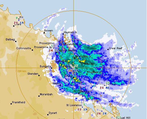
Head weather analyst Philip Duncan says live rain radar images clearly show the centre of the storm moving inland. “The cyclone has made a direct hit between Proserpine and Bowen on the Queensland coast”.
Full details, news, live rain radar, weather maps below…
The town of Bowen has around 7500 people and was the main setting for the epic romantic film “Australia” starring Nicole Kidman and Hugh Jackman.
Bowen is also near the major tourist region of the Whitsunday Islands and Hamilton Island.
Mr Duncan says the eye of the cyclone is roughly 65kms wide which means between 11,000 and 20,000 people will be directly affected by the worst of the storms winds. The hurricane force winds could affect as many as 200,000 people with the city of Townsville expected to receive severe gales shortly.
“Very destructive” winds up to 205km/h are being predicted by Australia’s Bureau of Meteorology (BOM) for communities near the centre of the storm when it makes landfall.
Philip Duncan says Ului could bring “significant destruction” to areas near the centre of the storm. “Winds this strong may bring destruction to crops, plantations, coral reef, beach communities and holiday resorts. The torrential tropical rain, combined with a wet summer, may also cause major flooding”.


Image: Severe Tropical Cyclone Ului, Cat 3 again, zeros in on Queensland coast earlier this evening. Image / GOES, NOAA
WeatherWatch.co.nz will bring you extensive coverage overnight tonight as the cyclone moves in.
Check back for regular updates.
LIVE RAIN RADAR: Click to animate with the latest images
LATEST WARNINGS FROM BOM – Please note all times quoted are Queensland times which are hours behind NZ
LATEST WARNING FROM BOM
TOP PRIORITY
TROPICAL CYCLONE ADVICE NUMBER 20
Issued by the Bureau of Meteorology, Brisbane
Issued at 12:52am EST on Sunday the 21st of March 2010
A Cyclone WARNING continues for coastal areas from Cardwell to Yeppoon and inland to Hughenden, including Charters Towers and Clermont.
At 12:00 am EST Severe Tropical Cyclone Ului, Category 3 was estimated to be 130 kilometres north of Mackay and 260 kilometres east southeast of Townsville and moving west at 30 kilometres per hour.
At 1:00 am EST the cyclone is estimated to be 69 kilometres east of Bowen and 125 kilometres north northwest of Mackay.
The cyclone is currently crossing the Whitsunday Islands as a severe tropical cyclone and is expected to move west and make landfall Bowen and Proserpine in the next hour. The cyclone is then expected to weaken as it moves inland later today.
VERY DESTRUCTIVE wind gusts to 200 km/hr near the cyclone centre currently affecting the Whitsunday Islands and will affect coastal and island communities between Ayr and Seaforth over the next few hours.
DAMAGING winds are expected in areas between Cardwell and Yeppoon over the next few hours, then extending to adjacent inland parts during today.
TIDES between Bowen and St Lawrence are expected to rise above the highest tide of the year overnight with very rough seas and dangerous conditions along the foreshore.
HEAVY RAINFALL and flooding are likely to continue about coastal and adjacent inland areas between Bowen and St Lawrence.
DANGEROUS SURF conditions are expected to continue about exposed beaches south of the cyclone until later today. A separate Severe Weather Warning is current for these conditions.
Details of Severe Tropical Cyclone Ului at 4:30 am NZT:
- Centre located near…… 20.0 degrees South 149.2 degrees East
- Location accuracy…….. within 30 kilometres
- Recent movement………. towards the west at 30 kilometres per hour
- Wind gusts near centre… 205 kilometres per hour
- Severity category…….. 3
- Central pressure……… 965 hectoPascals

LATEST CHART, posted 2:30am NZT
Comments
Latest Video

Cold weekend, frosts return with high pressure, then a low late next week
The subantarctic airflow spreads over NZ today/tonight and into Saturday, dropping temperatures nationwide. Snow flurries are possible today to lower…
Related Articles

Snow, rain showers & cold polar southerlies set to return
Friday will be a wintry day across NZ as the next cold front arrives, bringing snow to lower levels of…

Polar airflows set to bring cold weekend to NZ
Nor-west winds will be building over parts of NZ going into Thursday with rain on the West Coast becoming heavy…

ClimateWatch: JULY outlook & what El Niño means for NZ
El Niño is officially here and still getting stronger in the months ahead, but it’s harder to notice its effects…


Bowen Person on 20/03/2010 2:55pm
Winds here are strong at the moment but nothing too out of the ordinary, blowing in from the west which is very rare for Bowen. We are experiencing little rain not much more than a drizzle. I expect things will heat up a bit soon however so I will let you know if things start to get hectic.
Btw I searched Tropical Cyclone Ului in google to try and get a bit more info and your website poped up. Was glad to see you had some reliable information and outside opinion on the situation so I thought I’d just drop a comment. Will update later cheers.
Bowen Person on 20/03/2010 1:05pm
Hey I live in Bowen and on the beachfront too so this should be interesting. Unlikely it will progress to a cat 4 as it is 146km east of here headin west at 31kmh so i dont think thats enough time for it to intensify too much, that being said though the wind speed predictions have gone from 105kmh to 200kmh in the last 6 hours so who knows…wish me luck ppl 😀
WW Forecast Team on 20/03/2010 1:39pm
HI,
Thanks very much for your update. If your power supply lasts please post updates as to how the storm is progressing and what conditions are like where you are – ie, wind speed, rain, noises etc.
We wish you all the best – we agree, it won’t progress to a Cat 4 thank goodness.
Cheers
Philip Duncan
Btw – how come you know of our site, being from Bowen? Just interested to know!
Toni on 20/03/2010 12:39pm
You can see the eye on the bom satellite loop now!
Guest on 20/03/2010 12:09pm
Hi! Why no catergory on bom latest track? Is it going to hit cat 4 do you think?
WW Forecast Team on 20/03/2010 12:17pm
Hi there, no it’s unlikely Ului will make cat 4 as it’s still only a "weak" cat 3 storm and now with the land to the east impacting the cyclone it is very unlikely it can strengthen any further. Land kills cyclones so we’re probably seeing the peak of the storm now, or at least in the next hour or so.
– WeatherWatch
Craig on 20/03/2010 10:22am
I found a 60sec webcam working in Mackay, Queensland. Not that you can see much of course but the street lamps help illuminate things:
Wackado Web Weather
They also have a link to their ‘Current Weather Averages – Previous 15 minutes’
Melissa on 20/03/2010 9:27am
I see that BOM are predicting wind gusts of approx 165 kph near the centre of the cyclone, I always thought of a TC as being a constant wind speed ie a wall of wind? I suppose as the whole system turns and moves and as the pressures changes that it would vary to some extent. But I was wondering what the minimum wind speed be, in between the gusts? The eye of the storm would be calmer for maybe how long?, if at all.?
WW Forecast Team on 20/03/2010 9:56am
Hi Melissa,
Unlike other tropical storm authorities, such as America’s National Hurricane Centre, BOM measures wind gusts and publicises them rather than sustained winds. Unsure why that is.
However with a storm like this you can expect sustained winds of 118 – 159 km/h. BOM describe these winds as being strong enough to cause "Some roof and structural damage. Some caravans destroyed. Power failure likely".
When you think about those winds as SUSTAINED it makes you realise just how strong this storm is. In NZ we almost never see sustained winds that strong – we usually only see gusts only.
This storm doesn’t really have an eye but the centre will certainly have calm winds… possibly as light as a sea breeze. Sometimes in New Zealand we see this when a low passes over… the centre can be very calm. This happened a few months back when a low passed over Auckland bringing mostly calm weather while Taranaki, on the southern side of the low, had gales gusting to 100km/h.
The calm weather can last anywhere between a few minutes or up to an hour. This storm is moving very fast – closing in on 30km/h – so most places won’t experience calm winds probably.
– WeatherWatch
View more comments