
> From the WeatherWatch archives
#Yasi — “If people on the coastline haven’t heeded calls to evacuate to a safe place they may well not survive the night”
Below: Latest Maps, extensive news and weather readings.
Gale force winds and monster seas are now pushing into Queensland just hours ahead of Intense Tropical Cyclone Yasi, reports WeatherWatch.co.nz.
Powercuts are already affecting thousands and Sky News is now reporting that police are turning people aware from petrol stations.
A little earlier this evening authorities told residents that it was too late to escape the cyclone and to find shelter in their towns immediately.
Video: Live streaming from car in Townsville
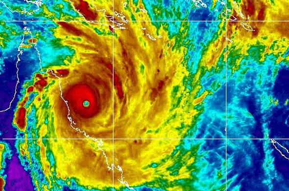
The cyclone is 200 to 250kms off the coast and will be making landfall in 4 or 5 hours.
View the latest rain radar: www.bom.gov.au/products/IDR191.loop.shtml#skip
The storm surge may well be the deadliest feature of the storm, with waves as high as street lights and a storm surge as high as houses.
“We are going to see entire coastal communities completely wiped from the earth tonight. Some people who evacuated their homes will return to an empty section” says WeatherWatch.co.nz head weather analyst Philip Duncan.
That was the case in Louisiana in 2005 with Hurricane Katrina made landfall. Suburbs, once lined with two storey homes, became streets filled with empty properties and only concrete foundations left.
Follow our Breaking Weather News on FACEBOOK – Simply click here!
Yasi is already causing damage too. Damaging gales are hitting Cairns and southwards with conditions becoming catastrophic later tonight.
And Mr Duncan says Yasi is going to be more powerful than Katrina was at landfall. “Katrina weakened a fair bit just before landfall. Yasi is not weakening and may actually strengthen further. There could not be a worse prediction”.
“Phones, power, cellphones will all go out. Completely darkness, the sea pushing in for kilometres inland in some places and winds that are stronger than many tornados. This will be a living hell for those in the middle of it” says Mr Duncan.
He says if people on the coastline haven’t heeded calls to evacuate to a safe place they may well not survive the night.
The town of Innisfail is expected to receive the most severe damage. In the past hour the Bureau of Meteorology have tweaked their landfall map, shifting the target zone back north, and placing it directly over the town of Innisfail.
The centre of the eye is 50kms wide. If Yasi does make a direct hit Innisfail residents can expect an hour of calm weather and clear skies as eye of the storm moves over – then the same strength winds and rain will hit from the opposite direction. Residents are warned not to leave their homes during this period as the returning winds will hit with no warning and will be just as deadly.
The Joint Typhoon Warning Centre says Cyclone Yasi will not weaken before landfall, like other cyclones, and may instead strengthen further.
Winds at the centre of the cyclone are gusting to almost 300km/h and the air pressure remains between 924hPa and 930hPa.
The eye is impressive and powerful and will literally wipe parts of the coastline clean, reports WeatherWatch.co.nz.
WeatherWatch.co.nz also says the cyclone will destroy large portions of the Great Barrier Reef – some parts may never recover, while others will take decades to repair.
Australian Authorities have now extended their initial comments of this being the largest cyclone to ever hit Queensland, to the most powerful cyclone to ever hit Australia.
Latest infrared map – click to animate.

Latest tracking
Comments
Latest Video

Cold weekend, frosts return with high pressure, then a low late next week
The subantarctic airflow spreads over NZ today/tonight and into Saturday, dropping temperatures nationwide. Snow flurries are possible today to lower…
Related Articles

Snow, rain showers & cold polar southerlies set to return
Friday will be a wintry day across NZ as the next cold front arrives, bringing snow to lower levels of…

Polar airflows set to bring cold weekend to NZ
Nor-west winds will be building over parts of NZ going into Thursday with rain on the West Coast becoming heavy…

ClimateWatch: JULY outlook & what El Niño means for NZ
El Niño is officially here and still getting stronger in the months ahead, but it’s harder to notice its effects…


David on 2/02/2011 10:24am
Clearly the aussies have completely forgotten about Cyclone Monica from April 2006, that hit a remote area of the Northern Territory east of Darwin, with wind gusts approaching 350kph. JTWC published sattelite based estimates of Monica’s central air pressure at peak intensity at 868 millibars, although the BOM never estimated the air pressure lower than 905 millibars
It’s probably because Monica hit a remote, sparsely populated area and did comparatively little damage that it has been forgotten, Yasi is heading for a more densely populated area and I agree it could become the most destructive storm in Australian history, both in terms of lives lost and damage to property and infrastructure.
I still remember the storm surge from a weakening Katrina in 2005 hit 10+ metres above normal high tide level over a wide area. With huge waves on top of that that is scary stuff. Yasi is similar in size to Katrina, whilst still a bit down on strength from Katrina at her peak, and will definitely bring a significant storm surge. My thoughts are with those people in northern Queensland on this awful awful night.