Big low on Monday bringing in a cold change for the south
17/06/2018 12:01am

> From the WeatherWatch archives
A big low pressure system moves out of the Tasman Sea on Monday with its centre passing over central New Zealand later in the afternoon / evening. This low will usher in southerlies over the South Island and a northwest airflow for the North Island.
One of the main features of this low wil be some heavy rain moving through about Auckland southwards from late morning then easing by evening. Taranaki in particular is looking likely to get heavy falls and thunderstorms then easing during the afternoon. Nelson and Marlborough in the South Island sees some heavy rain develop early afternoon also then easing in the evening.
The second main part of this low will be the drop in temperatures for the South Island later in the day. This more or less will be typical of a cold southwest in winter for the eastern South Island. Expect some snow for the ski fields and on other inland mountain ranges. Sea level snow is not looking to be in the equation.
So rug up for some unsettled weather early this coming week. A sub tropical low to the north of the country may be something to keep an eye on mid week for the North Island, at this stage heavy rain for Northland looks possible. Ridging brings mainly settled conditions to the South Island mid week onwards, this spreads onto the North Island later next week.
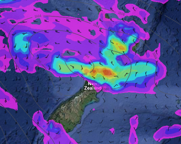
Image: Monday 18th June 2018 3:00pm MSLP / Rain map – weathermap.co.nz
WeatherWatch.co.nz
Latest Video

Cold weekend, frosts return with high pressure, then a low late next week
The subantarctic airflow spreads over NZ today/tonight and into Saturday, dropping temperatures nationwide. Snow flurries are possible today to lower…
Related Articles
Cold weekend, frosts return with high pressure, then a low late next week
The subantarctic airflow spreads over NZ today/tonight and into Saturday, dropping temperatures nationwide. Snow flurries are possible today to lower…

Wintry burst of weather: Snow, squally showers then sunshine & frosts
A polar change (another one!) arrives on Friday for the South Island and goes nationwide on Saturday, leaving NZ under…

Antarctic southerly for parts of NZ Fri & Sat
For the first time this year a southerly from off Antarctica is heading towards the South Island, followed by more…

