
> From the WeatherWatch archives
All the computer models are now agreeing that a tropical cyclone is imminent between Vanuatu and Fiji within the next 12 to 36 hours, reports WeatherWatch.co.nz.
The two mainstream global models that we rely on are predicting a tropical cyclone due north of New Zealand and tracking south east.
The likely severe cyclone isn’t expected to weaken as it heads south either, with WeatherWatch.co.nz predicting the storm will likely make Category 4 strength, with winds gusting as much as 280km/h over the open waters.
But a large high centred thousands of kilometres from the low will be New Zealand’s saving grace says Head Weather Analyst Philip Duncan. “Cyclones can’t survive in high air pressure. They chose the path of least resistance and behave quite differently from the usual lows we see near New Zealand. This large high to our west should be strong enough to guide this tropical storm well to the east of New Zealand, however if the high weakens at all it could increase the chances of the storm tracking closer to our east coast”.
Mr Duncan says the storm should maintain “tropical cyclone” status as it heads into New Zealand waters around Wednesday next week.
The sea surface temperatures east of East Cape remain in the low to mid 20s but the temperatures rapidly drop south of that, which is when the storm is likely to transition into an extratropical cyclone (this is when the core of the storm shifts from being warm to cold).
It’s likely the ex-cyclone will pass very near the Chatham Islands.
Big seas are still expected to be the main feature around eastern parts of the North Island.
WeatherWatch.co.nz will have regular updates across the weekend and into next week as this tropical cyclone develops and heads out of the tropics and into New Zealand waters.
The pending cyclone is still not likely to hit New Zealand despite its very close proximity.
Maps

Wind map 1pm, Thursday – Weathermap.co.nz
.jpg)
Fiji Meteoroligcal Service – chances of a cyclone on Monday
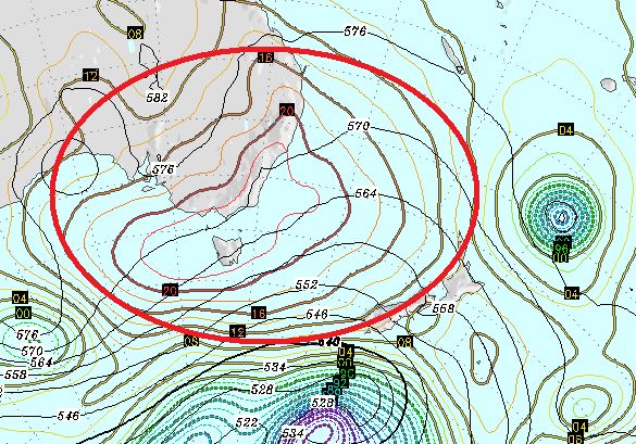
GFS map – we’ve highlighted the large high that is acting as a brick wall, stopping this potential cyclone from hitting NZ

Current Sea Surface temperatures – Weathermap.co.nz
Comments
Latest Video

Wintry weather coming: Snow, rain, wind & sunshine
A cold front is moving into NZ from Friday to Sunday with low pressure developing west of NZ and then…
Related Articles
Wintry weather coming: Snow, rain, wind & sunshine
A cold front is moving into NZ from Friday to Sunday with low pressure developing west of NZ and then…

ClimateWatch: JULY outlook & what El Niño means for NZ
El Niño is officially here and still getting stronger in the months ahead, but it’s harder to notice its effects…

Low pressure heading to NZ this weekend & into next week
Many regions have settled weather at the moment with frosts as far north as Auckland this morning, but still some…


Guest Peter on 18/02/2011 11:08pm
I note that NZ Met. Service is also showing a strong eastward movement of anticyclonic ridging at around the 30 to 40 deg latitude extending from the Australian Bight across the Tasman Sea. If it keeps up its forecast movement then it seems to me that it will block the projected cyclone track as illustrated. If that occurs then surely this cyclone will tend to slowly but surely move in a westward direction. Hence my forecast of a second Tasi type cyclone to hit notheastern Australia within a week. I don’t mind being proven wrong!!
Nicola on 19/02/2011 12:40am
Surely a high moving east towards the cyclone is going to push the cyclone further east, not west at all. My money’s still on Weather Watch
WW Forecast Team on 19/02/2011 12:43am
The Coral Sea is looking spectacularly quiet at the moment. After this new cyclone departs the tropics north of us will go quiet for a while (perhaps a week) but the air pressure remains low across the region – meaning another tropical depression could be likely in the next week or two. But at this stage there is no firm evidence of any new large scale lows forming to our north or north west.
– WeatherWatch Weekends