
> From the WeatherWatch archives
Eastern Australia’s set up of a blocking high to the east with sub-tropical downpours being fed from the north is heading to the North Island this Sunday and Monday says WeatherWatch.co.nz. With it comes the chance of localised flooding.
A low in the Tasman Sea will deepen today and Friday and spread into the North Island on Saturday and Sunday.
By Sunday an airflow from near Fiji will be spreading south over the North Island with localised heavy falls which may create pockets of flooding. Many others will have cloud and drizzle or showers.
While it’s not a repeat of the so called ‘Tasman Tempest’ it is a smaller, similar, set up with the same regions at risk from periods of sub-tropical rain.
And there’s another concern. The wet set up might linger.
“As we saw in Australia over the past 10 days the downpours have stuck along the east coast, held in place by a blocking high to the east while that same high then fed in the sub-tropical air” says head weather forecaster Philip Duncan. “Some models are suggesting this could happen in New Zealand next week too, with a high to our east blocking and feeding pockets of heavy rain into the northern North Island from Sunday to Wednesday”.
“We still need to see a few more updates, but we’re just suggesting the risk for flooding is there again, even if hit and miss/isolated”.
WeatherWatch.co.nz is also advising Aucklanders to prepare for more water savings with the water treatment plants already under pressure from flooding rains earlier this month.
The high humidity expected next week will also be of concern for farmers dealing with facial eczema in stock.
Grape growers will also be concerned with a wet, humid, spell of weather around now as harvesting continues.
South Islanders aren’t so much impacted by this low, although some patchy rain or drizzle may brush some areas for a time, especially in the north or west.
Dry weather returns later next week for most of New Zealand.
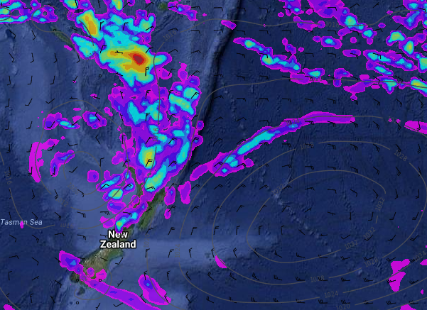
– Image / Next Monday Morning’s rain map shows a tropical flow from Fiji to New Zealand producing high humidity, low cloud, drizzle and pockets of heavy rain while a very large blocking high to the east holds the rain in place over the upper North Island / Weathermap.
– WeatherWatch.co.nz
Latest Video

Cold weekend, frosts return with high pressure, then a low late next week
The subantarctic airflow spreads over NZ today/tonight and into Saturday, dropping temperatures nationwide. Snow flurries are possible today to lower…
Related Articles
Cold weekend, frosts return with high pressure, then a low late next week
The subantarctic airflow spreads over NZ today/tonight and into Saturday, dropping temperatures nationwide. Snow flurries are possible today to lower…

Wintry burst of weather: Snow, squally showers then sunshine & frosts
A polar change (another one!) arrives on Friday for the South Island and goes nationwide on Saturday, leaving NZ under…

Antarctic southerly for parts of NZ Fri & Sat
For the first time this year a southerly from off Antarctica is heading towards the South Island, followed by more…

