Are droughts starting to develop in parts of NZ? We examine as March kicks off very dry (+5 Maps)
24/02/2019 11:14pm

> From the WeatherWatch archives
The Tasman Sea is being dominated by high pressure and it’s killing off our rainmakers with more of the same to come in the start of March according to WeatherWatch.co.nz.
The long range forecast for New Zealand looks to be a continuation of the pattern we’ve had since January – a lot of dry high pressure dominating from the Tasman Sea area with the occasional southerly cold front clipping southern New Zealand. The southerly we have today, Monday, is a nationwide one but fades tomorrow as high pressure again balloons back in from the west.
Head forecaster Philip Duncan says it was high pressure that stopped Cyclone Oma from tracking our way and was the same high that tore Oma apart. “If you watched Oma’s two week life in a short animation she was a slow motion low dropping south towards NZ then ‘bouncing’ back north after touching the the top of the high currently over the Tasman. When you speed up two weeks it looks like a ball being bounced” says Duncan. The remnants of Oma are now unravelling and weakening significantly near New Caledonia, losing its technical “tropical” status on Saturday as it was ripped apart by this high.
Now the high coming in looks set to bounce another tropical trouble maker away from NZ – and the rain it brings down with it from the north east later this week. “Long range data shows some parts of New Zealand, perhaps our driest regions, will have the lowest rainfall totals in the next two weeks ahead, some will have 0 to just 10mm in the next 14 days” says Mr Duncan, who last week pushed back at the ‘big’ forecasts by NIWA and MetService talking about a ‘weekend storm’ and heavy rain across New Zealand.
In fact second tax owned Government forecaster NIWA (who now directly competes with tax owned forecaster MetService to be in the news) said last week to MediaWorks and Newshub that Oma was likely to bring “flooding and destruction similar to that which Cyclone Gita delivered last year”, which caused a lot of public confusion and concern last week and into the weekend and prompted WeatherWatch.co.nz to publicly tell NZers not to believe all the “hype”.
For now most places actually look drier than normal over the next couple of weeks with just the odd cold front for the South Island and a few showers here and there in the North Island. The tropics are still quite active so for now the best bet for rain is hoping for a break in the belt of highs in mid-March and hoping a southerly and tropical low can pull in some nationwide soaking rains around then. This isn’t locked in but we do see a possible chance for rain around then. WeatherWatch.co.nz will keep you posted.
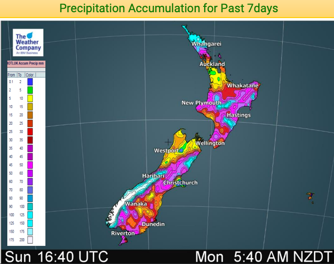
ACTUAL RAINFALL FROM THE PAST 7 DAYS
TOTAL FORECAST RAINFALL FOR THE NEXT 7 DAYS
GFS (American Government)
EMCWF – NEXT 7 DAYS (Europe)
TOTAL FORECAST RAINFALL FOR THE NEXT 14 DAYS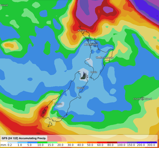
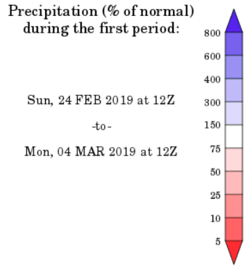
NEXT 7 DAYS RAINFALL COMPARED TO NORMAL…Note the blue patch north of NZ, that’s the remnants of Cyclone Oma. (Map courtesy of the US Government)
– WeatherWatch.co.nz
Comments
Latest Video

Cold weekend, frosts return with high pressure, then a low late next week
The subantarctic airflow spreads over NZ today/tonight and into Saturday, dropping temperatures nationwide. Snow flurries are possible today to lower…
Related Articles
Cold weekend, frosts return with high pressure, then a low late next week
The subantarctic airflow spreads over NZ today/tonight and into Saturday, dropping temperatures nationwide. Snow flurries are possible today to lower…

Wintry burst of weather: Snow, squally showers then sunshine & frosts
A polar change (another one!) arrives on Friday for the South Island and goes nationwide on Saturday, leaving NZ under…

Antarctic southerly for parts of NZ Fri & Sat
For the first time this year a southerly from off Antarctica is heading towards the South Island, followed by more…


Guest on 26/02/2019 3:42am
got it wrong oma didn’t go to queensland
WW Forecast Team on 26/02/2019 3:48am
Hi there, Queensland was only one of several options – we never said Queensland was definitely getting it.
Cheers
WW
Guest on 25/02/2019 12:29am
Worry for you looking for rain when Omar could of ended the worry
WW Forecast Team on 25/02/2019 3:26am
You nailed it. If Oma had hit NZ would’ve had excellent rainfall (possibly too much of a good thing!).
Cheers
WW