
> From the WeatherWatch archives
A cold blast is coming thanks to a huge storm well south of New Zealand in the Southern Ocean. Between this storm and a large high over Tasmania a very windy, very cold, southerly blast will roar into the lower South Island on Thursday PM and head northwards giving much of New Zealand it’s first true wintry taste of 2017.
Not all of New Zealand will be hit by a cold blast – but all places should see temperatures drop between Thursday PM and Saturday for a time.
Daytime highs, at the warmest point on Friday and Saturday, may only reach 4 to 6 degrees for many southern centres with wind chills dropping below zero at times in Southland and Otago – the two regions most exposed to the blast. While cold, the rain, showers and snow will also likely end the big dry that has formed in Southland this year. It’s been the one New Zealand region that has stayed drier than normal through much of Autumn.
The south to south west flow will howl across the Southern Ocean with hurricane force strength over sea on Thursday and Friday. These winds will ease somewhat as the flow moves over New Zealand and starts to fan out a bit, but very cold gales are likely in exposed places of Southland and coastal Otago over Thursday and Friday as the main blast surges northwards and perhaps slightly more to New Zealand’s east.
By Friday the South Island will be very cold and by Saturday the colder air flow will also be impacting the North Island.
Snow is possible across alpine highways of the south from later on Thursday and across Friday and early Saturday morning.
In the North Island there is some chance the Rimutaka Highway and the Desert Road may have snow overnight Friday or on Saturday AM.
A large high will help ease this blast at the weekend – frosts may then become the next focus.
More details in our latest weather video which is now available to view – including a focus on the large Tasman Sea low crossing New Zealand over Wednesday bringing warm rains.
 NOON TODAY (TUESDAY) SHOWS THE INCOMING TASMAN SEA LOW AND SUBTROPICAL NORTHERLIES
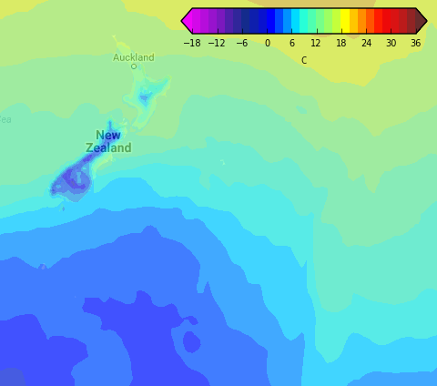
 NOON FRIDAY – A VERY COLD WET SOUTHERLY BLAST HITS SOUTHLAND & OTAGO AND MUCH OF THE SOUTH ISLAND IS COLD
 FRIDAY AFTERNOON SHOWS A SURGE OF COLD AIR SPREADING NORTH-EASTWARDS
 WINDY FRIDAY – AREAS IN PURPLE/GREY INDICATE HURRICANE FORCE WINDS AT SEA, MEANING THE SOUTH ISLAND WILL BE WINDY.
– Maps by Weathermap
– WeatherWatch.co.nz
Latest Video

Cold weekend, frosts return with high pressure, then a low late next week
The subantarctic airflow spreads over NZ today/tonight and into Saturday, dropping temperatures nationwide. Snow flurries are possible today to lower…
Related Articles
Cold weekend, frosts return with high pressure, then a low late next week
The subantarctic airflow spreads over NZ today/tonight and into Saturday, dropping temperatures nationwide. Snow flurries are possible today to lower…

Wintry burst of weather: Snow, squally showers then sunshine & frosts
A polar change (another one!) arrives on Friday for the South Island and goes nationwide on Saturday, leaving NZ under…

Antarctic southerly for parts of NZ Fri & Sat
For the first time this year a southerly from off Antarctica is heading towards the South Island, followed by more…

