Another warm day today and another cool night tonight (+3 Maps)
12/11/2018 10:36pm

> From the WeatherWatch archives
If you’re find the days warm and the nights cool, you’re not alone. Data WeatherWatch.co.nz exclusively used from IBM shows just how much warmer than average the days are with some inland parts of the South Island over 10 degrees above normal for this time of year.
Sea breezes around the country will also encourage hotter weather inland but some coastal fringes won’t be warmer than average and that includes where temperatures are “officially” taken at the airports in places like Auckland, Wellington, Tauranga and Napier. Hamilton, Palmerston North and Invercargill are the three cities most likely to enjoy temperatures well above normal for mid November.
These breezes will tomorrow put the Central North Island and South Waikato/King Country at risk of heavy afternoon downpours with thunderstorms.
But the nights are not so warm.
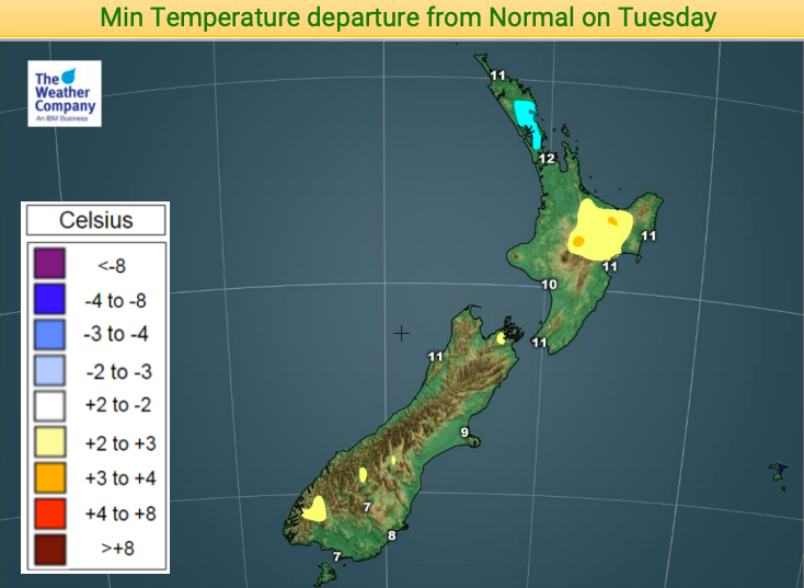
As we’ve been seeing lately the lighter winds and clearer skies can lead to cooler weather. Most of New Zealand will have average overnight lows tonight but some parts of Auckland and Northland will actually be cooler than normal.
This pattern looks set to continue for many places for the next week although overnight lows are likely to lift a bit in the nights ahead for some regions as westerlies pick up a little for a time. Calming high pressure returns next week and slowly tracks over New Zealand bringing more warm afternoons and cooler nights/mornings.


– WeatherWatch.co.nz
Latest Video

Cold weekend, frosts return with high pressure, then a low late next week
The subantarctic airflow spreads over NZ today/tonight and into Saturday, dropping temperatures nationwide. Snow flurries are possible today to lower…
Related Articles
Cold weekend, frosts return with high pressure, then a low late next week
The subantarctic airflow spreads over NZ today/tonight and into Saturday, dropping temperatures nationwide. Snow flurries are possible today to lower…

Wintry burst of weather: Snow, squally showers then sunshine & frosts
A polar change (another one!) arrives on Friday for the South Island and goes nationwide on Saturday, leaving NZ under…

Antarctic southerly for parts of NZ Fri & Sat
For the first time this year a southerly from off Antarctica is heading towards the South Island, followed by more…

