Amongst the milder weather, is a polar snap coming one week from now? (+3 Maps)
26/07/2018 8:43pm

> From the WeatherWatch archives
Technically we’re in the depths of winter but milder air is upon us coming from Australia with Central Otago having more nights above 0 degrees than below it in the week ahead and in the east of the North Island well above frost free with near double digit overnight lows and highs in the mid to late teens.
However as we mentioned yesterday at the end of next week it appears we may have a 48 hour period of cold weather and latest modelling continues to suggest a high over Tasmania shaped north to south could dredge up polar air over New Zealand.
WeatherWatch.co.nz says there is a lot of chaos in the Southern Ocean with some large lows coming in the week ahead while the bulk of large, more settled, high pressure systems remain well to New Zealand’s north. This set up is encouraging plenty of westerlies but the change later next week is that instead of these highs being north of New Zealand one may drop over Tasmania and break the westerly flow for a couple days, instead bringing in a polar southerly.
A week away in winter is a very long time with so much fast moving chaos, but at this early stage there could be a cold and low level snow event next Thursday and Friday with snow possible in Southland and Otago and maybe Canterbury too. Not yet locked in, but has been showing up for a few days now. We’ll keep you posted – there is always a chance this upcoming high won’t sink quite so far south and dredge up so much polar air, but based on the latest guidance there is a more than moderate chance of a polar blast for two days late next week and that is definitely worthy of focus amongst the warmer than usual headlines being generated this week. In fact sometimes extra warmth in winter can lead to much more snow when the mild air collides with polar air.
After this possible upcoming cold snap it may go frosty and sunny for another day or two next week, then it appears we’ll be back to a milder than usual air flow. Either way, welcome to the month of August – one of the most unpredictable months of the year.
NOON SATURDAY (shows milder westerlies over NZ)
NOON NEXT WEDNESDAY (Still showing mild westerlies over NZ)
NOON NEXT FRIDAY (Showing a potential polar southerly moving in due to the high over Tasmania)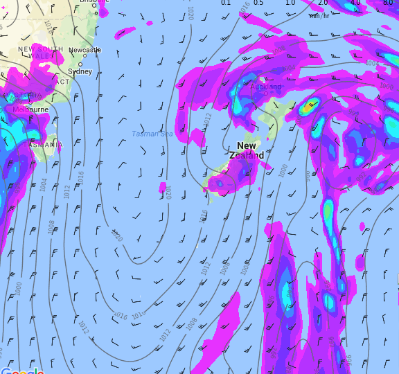
– Maps by Weathermap.co.nz
– WeatherWatch.co.nz
Latest Video

NZ: 8 Day outlook as gales & rain ease, high pressure builds
Damaging wind gusts and heavy rain will continue to affect some parts of the North Island and brushing Marlborough today…
Related Articles
NZ: 8 Day outlook as gales & rain ease, high pressure builds
Damaging wind gusts and heavy rain will continue to affect some parts of the North Island and brushing Marlborough today…

Pockets of hit & miss heavy rain, snow moves northwards
Low pressure continues to slowly move across the upper North Island and for some that will bring the sun out,…

Slow go for northern low & southern cold
For the next few days low pressure will crawl over the upper North Island, driving in rain as far south…

