
> From the WeatherWatch archives
We’ve had a taste of winter here and there over the past several weeks – some snow, some frost, some sub-zero daytime highs through inland parts of the South Island – but the weather change coming in overnight tonight in the south, then northwards on Thursday, is going to last a full seven days and bring an end to the mild weather.
That’s seven days of winds from the W, SW and S – and it will be significantly cooler than the sub-tropical northerlies many regions have been experiencing this winter and past autumn. But this is not a major wintry blast, in our opinion.
“The high in Invercargill today is 16 degrees – on Thursday it tumbles to just 8 degrees and the next week ahead mostly hovers around 9 and 10 degrees,” says head weather analyst Philip Duncan.
“Further north, and Dunedin, Christchurch and Wellington all have several days of highs around 11 to 14 degrees, which is fairly normal for mid-winter”.
Eastern parts of the North Island have mild westerlies this week, with highs around 15 to 17 degrees in places like Napier – but the cold change catches up to you too, with highs dropping to just 13 or 14 from the weekend and into next week.
Northern centres like Hamilton, Tauranga, Auckland and Whangarei will see mild temperatures (mid teens) this week but cooler air arrives during the weekend.
Mr Duncan says the wind chill will drop those highs another degree or two, maybe by more than a few degrees in the South Island, where the air is colder.
“The cold change, in our view, is not a major winter storm. In fact, it’s a normal winter system which may be the real shock to the system after such a settled, mild 2016 in some parts of New Zealand”.
Snow is likely in ski fields of both islands, which is very positive news for the school hols – and it will be accompanied by plenty of dry spells over the coming week (in between the showers and short-lived cold fronts!).
Snow may affect the Desert Road for a time on Monday too – as the coldest of the air surges into the North Island.
Overall this wintry system may bring a few problems here and there – but in our view it’s not at the severe end of the scale as far as winter systems go, it’s just going to be a wintry week ahead with isolated pockets of severe weather potential but also the potential for sun and calm too, amongst all the chaos.
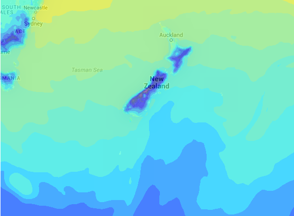
– Image / Midnight Saturday’s air temperature map clearly shows the colder southerly punching northwards / see our Maps tab for 14 days of air temp maps.
– WeatherWatch.co.nz
Comments
Before you add a new comment, take note this story was published on 12 Jul 2016.
Latest Video

VIDEO: Another big low late week brings severe weather risks to NZ
Severe weather is back in the forecast later this week after we kick off July with high pressure at the…
Related Articles
VIDEO: Another big low late week brings severe weather risks to NZ
Severe weather is back in the forecast later this week after we kick off July with high pressure at the…

VIDEO: NZ 7 Day: One big low, a high, then another big low
Severe weather risks continue around NZ’s two main islands for the rest of Friday and going into Saturday, before conditions…

VIDEO: Severe weather for parts of NZ, ahead of more high pressure
A large low in the Tasman Sea will bring further heavy rain and strong winds to western and southern parts…


Add new comment