A sub-tropical low + high pressure = Your Labour Weekend Forecast! (+7 Maps)
20/10/2021 12:05am

> From the WeatherWatch archives
Our first national holiday in almost half a year is upon us, and while nearly half of NZ’s population can’t head away this long weekend it’s still three days for many to switch off.
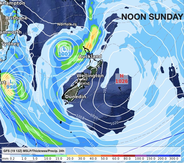
The forecast looks fairly typical for any long weekend in NZ – a low pressure zone is trying to move in while high pressure tries to push it back. The incoming low will increase: Cloud cover, nationwide temperatures and humidity for northern NZ. It will also increase the chance of showers, which may turn to patchy rain on Monday for northern and/or western areas.
However, with high pressure covering other parts of NZ the low is looking likely to fall apart. This means lower rainfall totals and not as windy as it could be. For some it may be cloudy and dry, others may enjoy plenty of sunshine with warmer winds from the north.
RuralWeather.co.nz is the best place to glance at forecasts this long weekend – the rain, cloud and wind graphs are all a good way at quickly seeing what is coming in. Don’t let the name fool you either, we also cover all the city suburbs and towns! If you don’t have the energy to switch sites, WeatherWatch.co.nz and our free app have all the same information in smaller bite sized pieces. Either way, we have you covered this long weekend.


To drill down deeper on a hyperlocal basis, see the rainfall totals at either WeatherWatch.co.nz or RuralWeather.co.nz – both powered by IBM.


Latest Video

Snow, rain showers & cold polar southerlies set to return
Friday will be a wintry day across NZ as the next cold front arrives, bringing snow to lower levels of…
Related Articles
Snow, rain showers & cold polar southerlies set to return
Friday will be a wintry day across NZ as the next cold front arrives, bringing snow to lower levels of…

Frosts, late week rain & another cold weekend coming
High pressure will cross NZ over the next few days meaning more cold nights/mornings with frosts, but a nor’wester will…

NZ: Cold & windy, then calm & frosty
Downpours, some squally with the chance of thunderstorms and even small tornadoes are possible for parts of NZ over Friday…

