
> From the WeatherWatch archives
A detailed update on ex-cyclone Victor, downpours in both islands, a cold change for Canterbury and more hot humid weather for the north:
A weakened ex-tropical cyclone will this week track right past East Cape in the North Island then move out well east of the country by the weekend. The low itself isn’t bringing a lot of weather with it – but the humidity it is pulling down from the tropics, combined with an incoming high pressure system over the South Island – means the entire nation will see changes to the weather pattern.
There is some heavy rain around the very centre of Victor, and this may brush East Cape, Gisborne and Hawkes Bay – and possibly parts of Bay of Plenty – but it looks quite short lived as the centre moves past.
But the very tropical air this low is pulling down to our east will combine with other air moving northwards from the South Island.
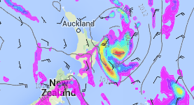
Basically it means the remnants of Victor plus this cold front could produce some heavier falls much further away from the centre – which you can see in this rain map over the lower North Island and up towards Northland, inland:
Rain map for 7pm this Wednesday / Weathermap.co.nz
Here’s a closer (below) look at the intense tropical rain around the centre at 4am on Thursday – it should move back out to sea again during Thursday morning if these models are correct. This would place East Cape, Gisborne and northern Hawkes Bay in the firing line for tropical downpours directly from ex-cyclone Victor.
There is a chance some of these slow moving downpours could prompt a warning or watch from MetService.
This afternoon MetService said the chance of a warning was “low” in their severe weather outlook for the country – but did make mention there was ‘low confidence’ Victor’s remnants could create heavy rain in some eastern areas of both islands.
(Map courtesy MetService – visit their website for full map and info)
Wind-wise and with ex-cyclone Victor’s centre weakening it means there isn’t much wind wrapped around the middle. However the pressure gradient between Victor moving south west into a high moving north east means a strengthening south east flow will cover New Zealand.

This wind map for 4am Thursday shows the strongest winds actually in the ‘squash zone’ between Victor’s remnants and the high approaching the South Island (windiest weather squeezing from the SE between Cook Strait).
This new wind flow means the South Island’s east coast is about to experience a drop in temperatures.
That’s right, Canterbury in an El Nino summer is usually associated with 30+ temperatures, clear skies and increasing droughts. This January, however, the rain is returning and the temperatures are about to drop.
On Tuesday a cold front moves northwards slowly across the South Island bringing rain to the West Coat and some patchy rain and showers to Canterbury. By Wednesday and Thursday colder air from the south east will blow through – dropping daytime highs to just 14 to 16 degrees and overnight lows down towards 10. Quite a contrast to northern New Zealand which will be around the late 20s with high humidity and ‘feels like’ temperatures around 35 degrees during the day and overnight lows around 20 degrees.

The temp map for Wednesday shows Canterbury in blue (single digits possible in the mountains during the day!) while the upper North Island has a ‘feels like’ temperature in the low to mid 30s.
After Victor the North Island may well see several days of unsettled weather with areas of slow moving showers or rain, while windier weather comes back to the South Island. Still plenty of hot, dry, summer weather coming in too – but it’s certainly not as dry, or settled, as previous recent summers.
– Maps via Weathermap, MetService
– WeatherWatch.co.nz
Comments
Latest Video

Cold weekend, frosts return with high pressure, then a low late next week
The subantarctic airflow spreads over NZ today/tonight and into Saturday, dropping temperatures nationwide. Snow flurries are possible today to lower…
Related Articles
Cold weekend, frosts return with high pressure, then a low late next week
The subantarctic airflow spreads over NZ today/tonight and into Saturday, dropping temperatures nationwide. Snow flurries are possible today to lower…

Wintry burst of weather: Snow, squally showers then sunshine & frosts
A polar change (another one!) arrives on Friday for the South Island and goes nationwide on Saturday, leaving NZ under…

Antarctic southerly for parts of NZ Fri & Sat
For the first time this year a southerly from off Antarctica is heading towards the South Island, followed by more…


Guest on 25/01/2016 7:19am
I am glad you guysbrung us this info .. Last week you did say “The System WILL track far to the East with NO affect to New Zealand” and i have followed you guys for years now, so i would have thought you would have mentioned that these storms are unpredictable and you cant say where it was going, and you didnt which is a little off putting. You guys do still do a general better job the MetService and other weather services 🙂
WW Forecast Team on 25/01/2016 9:08am
Hi there, thanks for your feedback and supportive comments!
In response to your points – the system IS tracking to the east, but yes it is tracking much closer than we thought it might 7 days ago. We definitely, repeatedly, said all ex-cyclones are unpredictable and to check daily for updates, because things can change. However as we said a week ago, this system would bring most of the risks to beaches – and that remains the case. Appreciate your feedback, and we’re the only ones who have been consistently reporting on this cyclone/ex-cyclone for a week now.
Cheers
WW