5 and 10 day NZ rainfall outlooks – many places look dry (+4 Maps)
26/11/2019 12:22am

> From the WeatherWatch archives
Heavy rain returns to the West Coast but elsewhere rainfall totals look set to remain below normal in many regions.
Driest places ahead will be eastern and northern New Zealand where rainfall totals over the next 10 days may be less than 10mm. In fact some eastern regions, especially Canterbury, may have less than 1mm.
As Australia’s dry weather spreads east over the Tasman Sea and affects the upper and eastern North Island it’s allowed for some rainmakers to come into Australia’s drought affected east. This set up is allowing rain to push back up NZ’s western coastlines but as it moves up the North Island later this week it runs into high pressure – which is why rainfall totals aren’t very high.
WeatherWatch.co.nz will release our first Summer and December forecast Wednesday morning with the climate outlook for the country over the next few months.
36 HOUR RAINFALL TOTALS:
ACCUMULATIVE RAINFALL NEXT 5 DAYS (IBM)
ACCUMULATIVE RAINFALL NEXT 10 DAYS (GFS)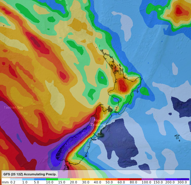
7 DAY RAINFALL OUTLOOK COMPARED TO NORMAL (Red = Drier than average, White = normal, Blue – wetter than usual). (US Govt)
– WeatherWatch.co.nz / RuralWeather.co.nz
Latest Video

Cold weekend, frosts return with high pressure, then a low late next week
The subantarctic airflow spreads over NZ today/tonight and into Saturday, dropping temperatures nationwide. Snow flurries are possible today to lower…
Related Articles
Cold weekend, frosts return with high pressure, then a low late next week
The subantarctic airflow spreads over NZ today/tonight and into Saturday, dropping temperatures nationwide. Snow flurries are possible today to lower…

Wintry burst of weather: Snow, squally showers then sunshine & frosts
A polar change (another one!) arrives on Friday for the South Island and goes nationwide on Saturday, leaving NZ under…

Antarctic southerly for parts of NZ Fri & Sat
For the first time this year a southerly from off Antarctica is heading towards the South Island, followed by more…

