Your official New Year’s EVE forecast + midnight temperatures and 5 Maps
31/12/2017 2:49am

> From the WeatherWatch archives
FINAL UPDATE — A front is moving into New Zealand bringing a cooler change in the south, some wet weather in the South Island and cloudy, mild and dry weather for most others.
The front will see areas of downpours, drizzle and light patchy rain moving around parts of the South Island this evening and also some parts of the North Island – although high pressure does hold on, keeping most wet weather offshore for the North Island.
There may be a bit of cloud around the country due to this set up – especially in the north, west and south.
Most main centres look dry but please check your local forecast for more details as we’re being quite general here. Dunedin and Wellington perhaps have the highest risk of a shower or a drizzle patch this evening.
Temperature-wise many in the north and east look mild but a cooler change is moving up the South Island.
TEMPERATURES:
North Island:
Daytime Highs: 20 to 26
Midnight temps: 15 to 20
South Island:
Daytime Highs: 16 to 24
Midnight temps: 12 to 17
Don’t forget WeatherWatch.co.nz has over 1500 forecast locations with the chance of rain in % form included for each town, suburb and most beaches and rural Kiwi Communities. If you use our website you can break those forecasts down to hourly (and we’ll be bringing this extra service to our app in the new year too).
Can’t find your nearest detailed 10 day forecast? Both our free app and our website has a “find your location” function where we can find the nearest forecast for your precise location in New Zealand. EXCLUSIVE to WeatherWatch.co.nz!!
 Forecast Rain Radar for 10pm New Year’s Eve shows some light patchy rain or drizzle in the central west and a cold front moving up the east coast of the South Island – but generally speaking many areas look dry or mostly dry – but many areas may be cloudy. There may be some heavy downpours on the West Coast.
 ABOVE: Tonight’s map before midnight shows a cold front moving up the South Island and weakening as a weak low remains in the Tasman Sea.
BELOW: 10pm New Year’s Day and the front continues to disintegrate as it heads northwards.
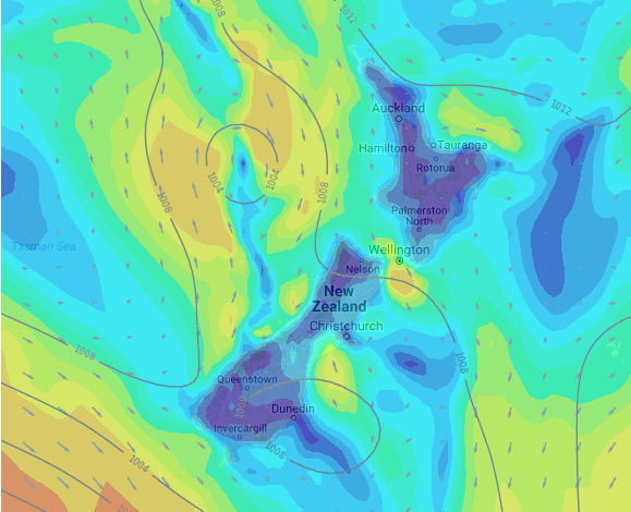
 Forecast Temperature Map for 7pm this evening shows the cold front lying somewhere around Canterbury with warmer weather to the north and cooler conditions moving in further south.
 Wind map for this evening shows a lot of calm weather but a cooler southerly may be blowing past Dunedin and hugging the east coast, while a brisk nor’west breeze blows through Cook Strait area. A light northerly quarter flow is continuing around northern NZ keeping conditions fairly mild.
– Maps by Weathermap.co.nz and The Weather Company
– WeatherWatch.co.nz (an official IBM business partner)
Latest Video

Cold weekend, frosts return with high pressure, then a low late next week
The subantarctic airflow spreads over NZ today/tonight and into Saturday, dropping temperatures nationwide. Snow flurries are possible today to lower…
Related Articles
Cold weekend, frosts return with high pressure, then a low late next week
The subantarctic airflow spreads over NZ today/tonight and into Saturday, dropping temperatures nationwide. Snow flurries are possible today to lower…

Wintry burst of weather: Snow, squally showers then sunshine & frosts
A polar change (another one!) arrives on Friday for the South Island and goes nationwide on Saturday, leaving NZ under…

Antarctic southerly for parts of NZ Fri & Sat
For the first time this year a southerly from off Antarctica is heading towards the South Island, followed by more…

