Why’s it so warm? It’s all due to one large high pressure system that’s now leaving (+3 Maps)
3/07/2019 7:00pm

> From the WeatherWatch archives
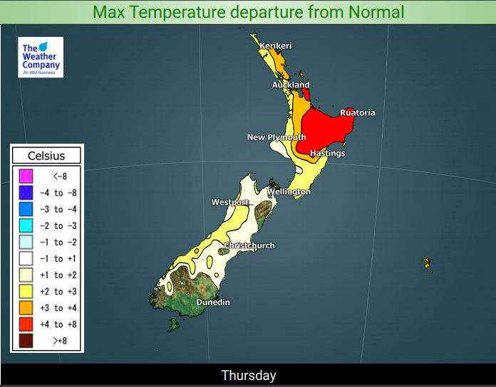
A cool down is coming but the warmer than normal sub-tropical air flow still covers the North Island for Thursday.
It’s quite a basic set up – an enormous high that has influenced New Zealand’s weather for a week and half now lies east of us. The size of this high means the anti-clockwise winds going around it are being pushed right up to Fiji, then pulled back down again over NZ. This has been the process since late Sunday but peaked over Wednesday and this morning in northern NZ.
So while Thursday is warmer than average in the north – Friday looks more normal, or cooler than normal, thanks to a southerly change coming in before the next big high nationwide.


– WeatherWatch.co.nz
Comments
Before you add a new comment, take note this story was published on 3 Jul 2019.
Latest Video

(VIDEO) NZ 7 Day: Variety in the weather, but Southern Ocean storms waking up
Low pressure moves in to NZ from the Tasman Sea this weekend and completely falls apart – bringing downpours and…
Related Articles
(VIDEO) NZ 7 Day: Variety in the weather, but Southern Ocean storms waking up
Low pressure moves in to NZ from the Tasman Sea this weekend and completely falls apart – bringing downpours and…

VIDEO: ClimateWatch: July is the month of BIG lows, BIG highs
This month around New Zealand, Australia and the region we see big highs and big lows – bringing decent stretches…

VIDEO: Severe weather risks for NZ as low moves in
Programming Note: Apologies but we have no video on Thursday – back again on Friday! – A storm in the…


Add new comment