Wednesday & Thursday several degrees warmer than average for some (+5 Maps)
14/11/2017 10:27pm

> From the WeatherWatch archives
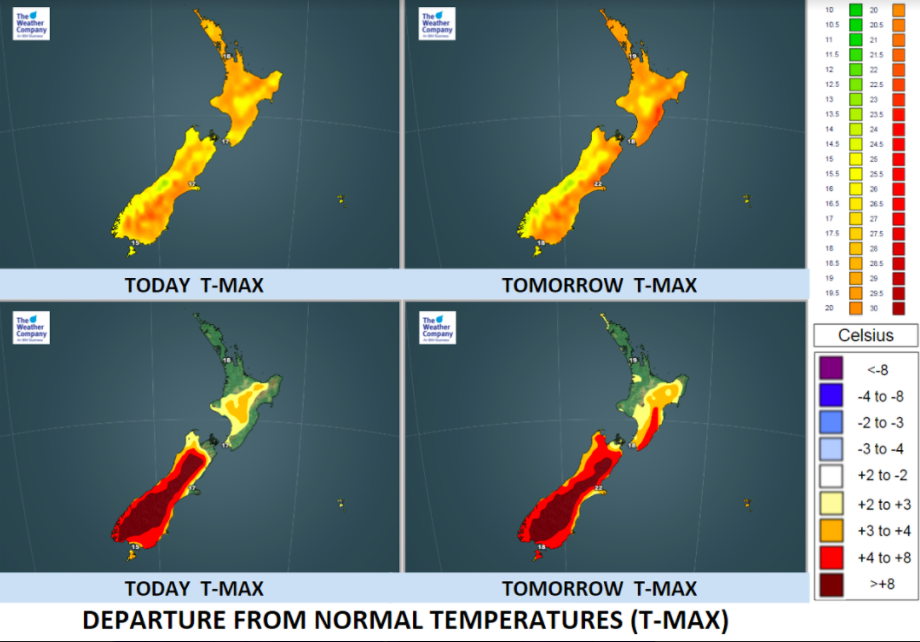
Thursday’s airflow is going to be a warm one for some parts of New Zealand, over 8 degrees above average for inland areas of the central South Island.
With high pressure dominating the country this week the set up on Thursday sees a slightly warmer air flow cross the country – a departure from the cooler southerly flow from last weekend and the very start of this week.
Daytime highs inland will climb into the mid 20s both today and tomorrow through Central Otago and other surrounding inland areas.
In the North Island today is a warm one but Thursday looks even warmer for the lower half of the island. This is why we’re seeing more downpours likely to pop up in the Central North Island on Thursday too.
The rain map below may not be 100% accurate (as big downpours can be very hard to perfectly lock in over an island) but it gives you a general idea as to where the heaviest downpours may pop up (even if not all get rain).

– Maps by The Weather Company (an IBM business & an official WeatherWatch.co.nz partner)
– WeatherWatch.co.nz
Latest Video

Cold weekend, frosts return with high pressure, then a low late next week
The subantarctic airflow spreads over NZ today/tonight and into Saturday, dropping temperatures nationwide. Snow flurries are possible today to lower…
Related Articles
Cold weekend, frosts return with high pressure, then a low late next week
The subantarctic airflow spreads over NZ today/tonight and into Saturday, dropping temperatures nationwide. Snow flurries are possible today to lower…

Wintry burst of weather: Snow, squally showers then sunshine & frosts
A polar change (another one!) arrives on Friday for the South Island and goes nationwide on Saturday, leaving NZ under…

Antarctic southerly for parts of NZ Fri & Sat
For the first time this year a southerly from off Antarctica is heading towards the South Island, followed by more…

