
> From the WeatherWatch archives
Some people have noticed that today’s weather map looks a little…well…like an ultrasound. As we transition out of February and into March all of New Zealand is under a large high pressure system.
The giant egg or rugby ball shaped high stretches wide from west to east and just reaches north and south enough to fit the entire country directly under it.
Most places have light winds but the anticyclonic flow means northerners are more likely to have easterlies while a light westerly is expected to develop this week in the lower South Island.
The easterly in the north is also helping push a small area of showers westwards from western Bay of Plenty into Waikato and brushing Coromandel Peninsula and parts of Auckland each day. This gentle easterly flow creates cloudy weather, especially in the afternoons as the easterly movement pushes these showers over much warmer air inland – creating the big but isolated afternoon downpours we saw on Monday and expect again today and Wednesday.
A fairy gentle sou’west flow will spread across much of the country around Friday or Saturday – ahead of the next high, coming in for the South Island mostly. Next week may see more sub-tropical airflows for the north of NZ.
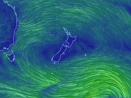


– Maps / Weathermap, earth.nullschool.net
– WeatherWatch.co.nz
Latest Video

Cold weekend, frosts return with high pressure, then a low late next week
The subantarctic airflow spreads over NZ today/tonight and into Saturday, dropping temperatures nationwide. Snow flurries are possible today to lower…
Related Articles
Cold weekend, frosts return with high pressure, then a low late next week
The subantarctic airflow spreads over NZ today/tonight and into Saturday, dropping temperatures nationwide. Snow flurries are possible today to lower…

Wintry burst of weather: Snow, squally showers then sunshine & frosts
A polar change (another one!) arrives on Friday for the South Island and goes nationwide on Saturday, leaving NZ under…

Antarctic southerly for parts of NZ Fri & Sat
For the first time this year a southerly from off Antarctica is heading towards the South Island, followed by more…

