
> From the WeatherWatch archives
Updated: 8:05pm — Heavy rain and strong winds are hitting Dunedin and coastal Otago tonight as an offshore low to the east grows in size and pushes back towards New Zealand.
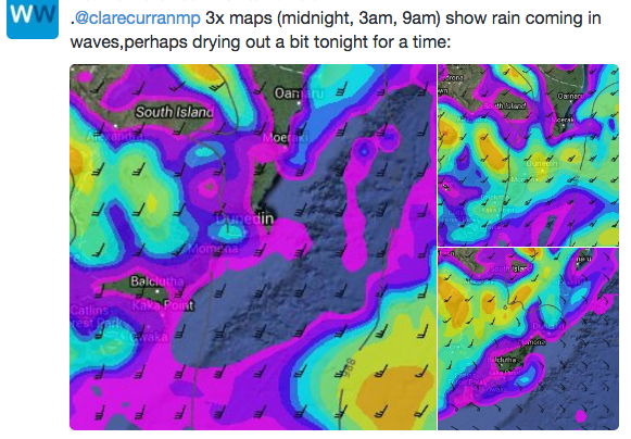
Tonight questions are coming in to WeatherWatch.co.nz with some concerned about flood risks, including Dunedin MP Clare Curran who tweeted “Hi @WeatherWatchNZ cant get any new info out of Met Service since this morning. Clearly Dunedites nervous re flooding. Anything new yr end?”.
Rain will come in waves tonight, with some big dry patches coming in this evening. After midnight and towards dawn there may be more heavy falls, but then we expect conditions to ease on Monday morning back to showers, then long dry spells hopefully develop into the afternoon and evening. There could be 25 to 30mm of rain overnight and Monday morning which hopefully will be below any concerning levels.
The next two days afterwards look dry or mostly dry.
For the most part we expect very strong winds tonight brushing the Otago coastline, but around dawn or Monday morning they ease back.
Meanwhile, in North Island news, there are reports of snow on the Rimutaka Ranges heavy enough to close the highway this evening, make sure you check with NZTA before driving, which currently calls for “winter driving” on the hill.
Below are some of our recent tweets with regards to Dunedin/Coastal Otago:


– WeatherWatch.co.nz
Comments
Latest Video

Cold weekend, frosts return with high pressure, then a low late next week
The subantarctic airflow spreads over NZ today/tonight and into Saturday, dropping temperatures nationwide. Snow flurries are possible today to lower…
Related Articles
Cold weekend, frosts return with high pressure, then a low late next week
The subantarctic airflow spreads over NZ today/tonight and into Saturday, dropping temperatures nationwide. Snow flurries are possible today to lower…

Wintry burst of weather: Snow, squally showers then sunshine & frosts
A polar change (another one!) arrives on Friday for the South Island and goes nationwide on Saturday, leaving NZ under…

Antarctic southerly for parts of NZ Fri & Sat
For the first time this year a southerly from off Antarctica is heading towards the South Island, followed by more…


Guest on 22/05/2016 9:32am
Aha!! I didn’t see any predictions for snow on the Rimutaka Hill Road for today, or the 4.7c temp we have in Porirua at the moment.
Am I using heating in May?
Why yes, the electric blanket is on and the Rinnai beast has been warming the house, only the 2nd time this year.
Looks like another interesting week ahead for us all.
Don’t you just love Autumn……..finally!!!