Tuesday’s national forecast – A cool change moves through (+6 maps)
15/03/2021 3:00pm
> From the WeatherWatch archives
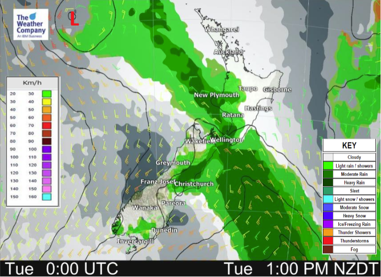
A southwesterly airflow over the South Island spreads over the North Island later this afternoon / evening.
Most regions see shower activity clear by this evening however a few showers linger overnight for coastal Southland, Northland. Showers move in this evening to the eastern North Island.
For wind and temperature information please see the forecasts below.
Please refer to your local, hourly, 10 day forecast for more details.
Northland, Auckland, Waikato & Bay Of Plenty
Sunny areas and increasing cloud, a few showers develop in the afternoon then clearing overnight. Northwesterlies change to the south in the evening.
Highs: 22-24
Western North Island (including Central North Island)
Sunny areas and increasing cloud, the odd shower about Kapiti and Taranaki then some rain develops in the afternoon, clearing evening as northwesterlies change southeast.
Highs: 18-21
Eastern North Island
Sunny areas and thickening high cloud, showers late afternoon for Wairarapa then further north in the evening with a cool southwest change.
Highs: 21-26
Wellington
The odd spit, turning to rain for a time in the afternoon then clearing evening. Brisk to strong northwesterlies change southerly mid afternoon.
Highs: 19-20
Marlborough & Nelson
Dry first thing then rain develops during the morning with gusty north to northwesterly winds, winds change southerly in the afternoon with rain clearing away and sun breaking through.
Highs: 21-22
Canterbury
A few showers moving in this morning, easing back to the odd spit late afternoon. Southwesterly winds.
Highs: 16-18
West Coast
Morning showers clear South Westland then sunny areas increase, heavy rain further north clears around midday. Southwesterly winds.
Highs: 18-19
Southland & Otago
Showers, mostly morning but a few may linger for the rest of the day especially near coastal areas. Sunny spells break through from afternoon, more so about Central Otago. Gusty southwesterlies, strong about the coast.
Highs: 14-18


Latest Video

More eastern rain, but a drier long weekend coming
Rain continues today along the eastern South Island and lower North Island, coming in from the east with heavy falls….
Related Articles
More eastern rain, but a drier long weekend coming
Rain continues today along the eastern South Island and lower North Island, coming in from the east with heavy falls….

More heavy rain, snow – but large dry areas, especially as we go into the long weekend
Heavy rain will continue for parts of Canterbury and Marlborough over the next day or two and it will gradually…

Large low brings rain, downpours & some snow – gets colder as the week progresses
Low pressure will cross the upper North Island in the days ahead and that set-up actually pushes more heavy rain…

