
> From the WeatherWatch archives
METSERVICE:
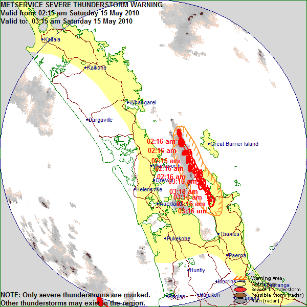
Metservice has issued a Severe Thunderstorm Warning early this morning for the Thames/Coromandel region.
SEVERE THUNDERSTORM WARNING
Issued by MetService at 02:26 am Saturday 15 May 2010.
Valid until 03:15 am Saturday 15 May 2010.
This warning affects people in the following local government areas: THAMES COROMANDEL.
At 02:15 am, MetService weather radar detected severe thunderstorms near LITTLE BARRIER ISLAND and OUTER HAURAKI GULF.
These severe thunderstorms are moving towards the southsoutheast, and are expected to lie near LITTLE BARRIER ISLAND, GREAT BARRIER ISLAND, OUTER HAURAKI GULF and CAPE COLVILLE at 02:45 am and near CAPE COLVILLE, COROMANDEL, MANAIA and COLVILLE at 03:15 am.
These thunderstorms are expected to be accompanied by very heavy rain.
Very heavy rain can cause surface and/or flash flooding about streams, gullies and urban areas, and make driving conditions extremely hazardous.
A Severe Thunderstorm Watch remains in force for AUCKLAND, BAY OF PLENTY, COROMANDEL PENINSULA, GREAT BARRIER ISLAND, NORTHLAND and WAIKATO.
The Ministry of Civil Defence and Emergency Management advises that as storms approach you should:
– Take shelter, preferably indoors away from windows;
– Avoid sheltering under trees, if outside;
– Move cars under cover or away from trees;
– Secure any loose objects around your property;
– Check that drains and gutters are clear;
– Be ready to slow down or stop, if driving.
During and after the storm, you should also:
– Beware of fallen trees and power lines;
– Avoid streams and drains as you may be swept away in flash flooding.
This warning is due to be updated or lifted by 03:15 am Saturday 15 May 2010.
TORNADOES
There are reports of tornadoes ripping through parts of Taranaki.
Small tornadoes have apparently been passing through between Oakura and New Plymouth.
The Oakura area has been without power and there are reports of structural damage to homes in the area.
This comes after a severe weather warning was issued for much of the North Island and upper South Island for the weekend.
Heavy rain and thunderstorms are expected at times through the weekend in the Bay of Plenty, Mt Taranaki, Nelson and northern parts of Marlborough.
MetService says some intense falls are possible in thunderstorms in all of these areas.
People are being warned that rivers and streams will rise rapidly and surface flooding is likely following heavy rain and thunderstorms.
– TVNZ
Comments
Before you add a new comment, take note this story was published on 14 May 2010.
Latest Video

VIDEO: Severe weather risks for NZ as low moves in
Programming Note: Apologies but we have no video on Thursday – back again on Friday! – A storm in the…
Related Articles
VIDEO: Severe weather risks for NZ as low moves in
Programming Note: Apologies but we have no video on Thursday – back again on Friday! – A storm in the…

VIDEO (NZ): Large low looms – who gets rain/wind & who does not
Another large low will bring severe weather to parts of both main islands of NZ this week, followed by a…

VIDEO: Another big low late week brings severe weather risks to NZ
Severe weather is back in the forecast later this week after we kick off July with high pressure at the…


Add new comment
Jamie of north shore auckland on 14/05/2010 2:53pm
Seeing some cool lightning over takapuna beach at 2.40 AM
Happening ever 1 min or so 😀
Reply
Hamish on 14/05/2010 8:18pm
Saw some good flashes from Howick and Pakuranga between 2.45am and 3.30am, but that was mostly from the storm headed out over the Coromandel and Hauraki Gulf.
Reply