
> From the WeatherWatch archives
A cold showery west to southwest flow is forecast to spread onto the southern South Island this afternoon and evening says government forecaster MetService.
They says the showers are likely to be heavy and squally, with possible small hail.
“There is a generally low risk of a few turning thundery about coastal parts of Fiordland, Southland and South Otago from later this afternoon through to tonight” says MetService. “The risk is nearer moderate about Foveaux Strait late this afternoon and evening. Any thunderstorms that occur are likely to produce brief heavy rain, small hail less than 10mm in diameter and wind gusts of 90 to 110 km/h”.
A few heavy showers are also possible about eastern Otago this evening and coastal parts of Canterbury south of Christchurch tonight, as a colder southerly change pushes north. There is a very low risk of one or two of these showers turning thundery during this time, as indicated on the chart.
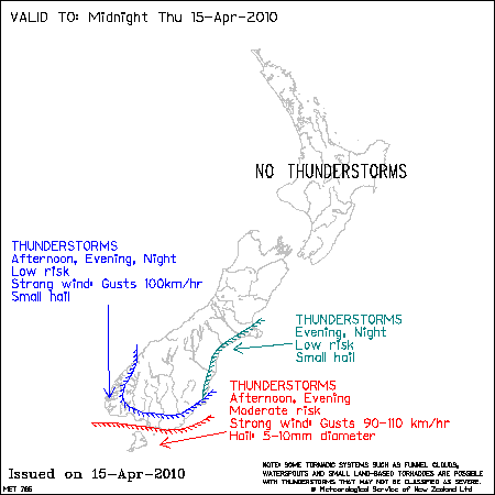
No thunderstorms or significant convection expected elsewhere.
Comments
Latest Video

Some polar airflows but more high pressure to affect NZ’s weather
Showers are in the forecast over the next several days, we track where and when they occur – but there…
Related Articles
Some polar airflows but more high pressure to affect NZ’s weather
Showers are in the forecast over the next several days, we track where and when they occur – but there…

Tracking the showers & colder changes
High pressure isn’t over NZ, but is nearby – and it’s affecting our airflows and who gets wet weather and…

Westerlies continue, sub-tropical for some
West to north-west winds blow through the South Island and lower North Island today bring heavy West Coast rain and…


Guest on 15/04/2010 8:27am
I doubt it.
JohnGaul
NZThS