The slide to summer – the Spring equinox is this Wednesday! (+6 Maps)
20/09/2020 10:18pm

> From the WeatherWatch archives
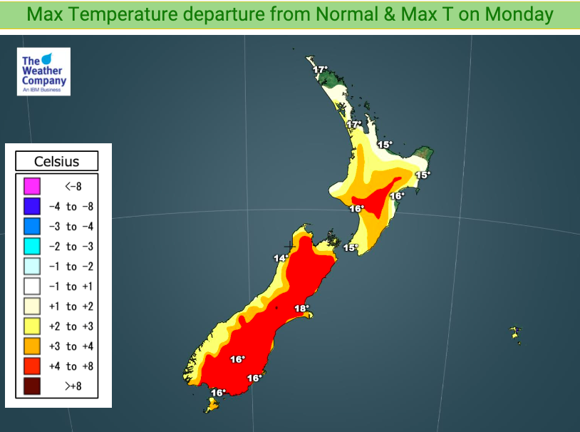
This week is warmer than average by several degrees in many regions as we pass the spring equinox on Wednesday and mild airflows from the sub-tropics, or simply mild nor’westers, continue to blow.
This year the equinox for New Zealand occurs at precisely 1:30am on Wednesday, September 23.
After this date the days continue to become longer than the nights right up until the end of December, just before Christmas.
However, summer is still over two months away and we’re only kicking off into true spring now, so expect more ups and downs – and a potential cold southerly is currently forecast for this Sunday and Monday. It may bring a burst of lower level snow and a big drop in temperatures. It also looks relatively short lived, for a day or so.
Spring is all about winter slowly fading away and hints of summer slowly coming in.


To drill down deeper, look at www.RuralWeather.co.nz – It’s the world’s most comprehensive weather data website for New Zealand.
Comments
Before you add a new comment, take note this story was published on 20 Sep 2020.
Latest Video

NZ VIDEO (7 Day): High pressure, frosts, expand as big lows surround us
Most of you will be pleased to know drier weather is coming for most parts of New Zealand. High pressure…
Related Articles
NZ VIDEO (7 Day): High pressure, frosts, expand as big lows surround us
Most of you will be pleased to know drier weather is coming for most parts of New Zealand. High pressure…

NZ: Frosts, high pressure, dry skies increasing – but what about next week?
Frosty weather is expanding this weekend with perhaps some of the coldest overnight weather the North Island has had so…

NZ VIDEO: Big frosts as high pressure flirts with NZ
A low will cross the North Island on Thursday while heavy frosts (-5C and below!) will affect inland parts of…


Add new comment