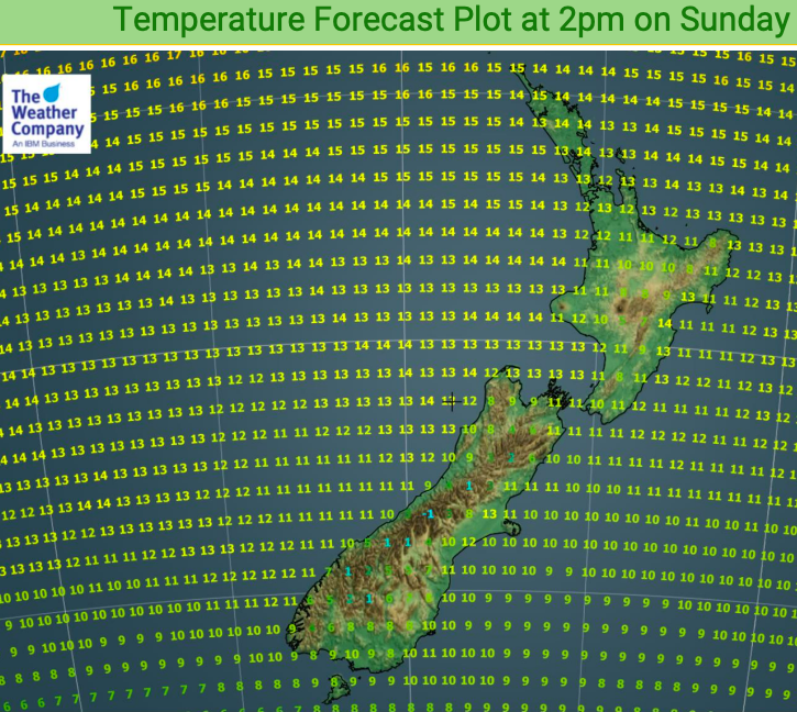
Temperature plots for Sunday ahead of a wintry Monday for some (+4 Maps)
6/07/2019 7:00pm

> From the WeatherWatch archives
Temperatures today may be a degree or two warmer for some regions but we have another injection of colder air coming this afternoon and overnight from the south.
There may be some frosts this morning and again tonight but for the most part they look light. However it will be colder than average tonight in many places. Before that happens, though, some places in the South Island may be a degree or two above normal this afternoon – but that’s ahead of this colder surge moving in to the lower South Island today and further northwards overnight.
Monday will be much colder in the deep south with a few snow flurries affecting some farms in Southland and Otago too. The North Island isn’t impacted by this brief colder change but Wellington and some other southern North Island regions may be down a couple degrees on Monday.


– WeatherWatch.co.nz
Comments
Before you add a new comment, take note this story was published on 6 Jul 2019.
Latest Video

NZ VIDEO: Westerlies, lows, showers & large dry areas
Messy westerly driven weather will affect NZ this week, bringing more wet weather to western and northern parts of the…
Related Articles
NZ VIDEO: Westerlies, lows, showers & large dry areas
Messy westerly driven weather will affect NZ this week, bringing more wet weather to western and northern parts of the…

NZ VIDEO: Westerlies continue
Heavy rain and northerly gales are moving across NZ going into the weekend as a large low from the Tasman…

VIDEO: Low pressure, cold fronts, main feature next two weeks
There are several low pressure zones and cold fronts coming into NZ, with westerly driven weather dominating our weather pattern…


Add new comment