Tasman Sea low finally moving into NZ, colder air to follow (+2 Infographic Maps)
14/05/2018 11:14pm

> From the WeatherWatch archives
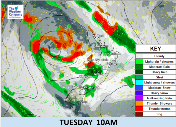
The much warmer than usual weather over parts of New Zealand is about to stop as a large low that’s been in the Tasman Sea for about a week finally moves onto the western side of New Zealand. Overnight there were plenty of thunderstorms at sea to the west which could be seen from Waikato and Auckland – over the next 24 hours some of these thunderstorms will cross land.
The centre of the low is being pulled to the south east, eventually tearing the low apart overnight. This stretching action of the centre will drag it through the Cook Strait area tonight and early tomorrow morning. Behind it comes a colder southerly that will see snow fall to 400m in the lower South Island.
Once the low has gone expect at least 7 to 10 days of cold fronts bringing snow to the mountains, ranges and ski fields and perhaps down to just a few hundred metres at times (or even briefly lower). Most fronts are fast moving and don’t contain huge amounts of moisture overall though.
Winds over the next 7 to 10 days will be mainly westerly quarter. This will make for some sunny, warmer than average days in the north east of the country but the sou’west changes that follow will be much colder.
The westerly theme looks set to blow through next week too.
If you’re trying to lock in specific rainfall times keep an eye on our rain maps and our hourly rainfall forecasts – but please note the next week and a half look very chaotic around New Zealand and a number of models show various lows suddenly forming – in other words, chaos. In the past couple of days alone computer models have been placing large lows which in following updates do not include. This shows there is plenty of energy around the country and plenty of change – but locking in more than a few days out in this type of set up can be tricky. We’ll keep you posted.
Please note the thunderstorm risk areas in the maps below are simply that – the area most at risk of thunderstorms. It doens’t mean everyone within those areas will have thunder as they randomly form.

– WeatherWatch.co.nz
Latest Video

Cold weekend, frosts return with high pressure, then a low late next week
The subantarctic airflow spreads over NZ today/tonight and into Saturday, dropping temperatures nationwide. Snow flurries are possible today to lower…
Related Articles
Cold weekend, frosts return with high pressure, then a low late next week
The subantarctic airflow spreads over NZ today/tonight and into Saturday, dropping temperatures nationwide. Snow flurries are possible today to lower…

Wintry burst of weather: Snow, squally showers then sunshine & frosts
A polar change (another one!) arrives on Friday for the South Island and goes nationwide on Saturday, leaving NZ under…

Antarctic southerly for parts of NZ Fri & Sat
For the first time this year a southerly from off Antarctica is heading towards the South Island, followed by more…

