Sunday’s national forecast – Each island is a nation of two halves (+7 Maps)
5/06/2021 4:00pm

> From the WeatherWatch archives
Isolated areas of heavy rain and strengthening winds are moving into parts of New Zealand today, while others have sunny and dry weather.
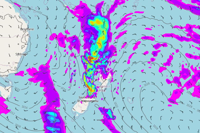
A powerful high pressure zone east of NZ and a deepening low just north of the North Island are combining to create windier weather for the top of the country but also increasing rain in the north and isolated downpours in the west.
The north of both islands are most exposed to the heavy falls, with Northland and Nelson getting up to 50mm today, and some areas may go higher (like the Nelson ranges). These totals are getting into the marginal territory for isolated flooding – so if you’re camping near streams or low lying areas in these zones please be aware heavier rain may be falling in the hills and ranges.
Eastern NZ is driest, from Gisborne right down to Dunedin and Southland.
Winds increase in the north with gales developing overnight in eastern Northland and some exposed parts of northern coastal Auckland and Great Barrier Island on Monday and Tuesday AM. Gusts on Great Barrier Island may even reach 120km/h with beaches becoming more dangerous in eastern areas too as waves/swells pick up.
Both main islands have split weather with rain in the north and mostly dry in the east and south.
Refer to your HOURLY and LOCAL forecasts for any location in NZ for more details from either WeatherWatch.co.nz, www.RuralWeather.co.nz or from our free weather app WeatherWatchNZ.


Latest Video

More eastern rain, but a drier long weekend coming
Rain continues today along the eastern South Island and lower North Island, coming in from the east with heavy falls….
Related Articles
More eastern rain, but a drier long weekend coming
Rain continues today along the eastern South Island and lower North Island, coming in from the east with heavy falls….

More heavy rain, snow – but large dry areas, especially as we go into the long weekend
Heavy rain will continue for parts of Canterbury and Marlborough over the next day or two and it will gradually…

Large low brings rain, downpours & some snow – gets colder as the week progresses
Low pressure will cross the upper North Island in the days ahead and that set-up actually pushes more heavy rain…

