
> From the WeatherWatch archives
February 28th marks the last day of Summer on the meteorological calendar, but the end of summer weather isn’t near with more highs and tropical weather coming our way.
In fact, for those who really don’t want to let go of summer it’s just as well the Astronomical end to the season (the earth’s rotation around the sun) isn’t for another 3 weeks, until the equinox on March 21st this year.
Meanwhile it’s not just dates on a calendar – the long range forecast supports the continuation of summer weather with more high pressure systems for the country, but the North Island needs to prepare for possibly losing the sunny, dry, weather.
“It’s early days but modelling we trust is once again picking sub-tropical rains to spread down over the North Island” says head weather forecaster Philip Duncan. “It looks as though the second week of March runs a fairly high chance of humid, sometimes very wet, weather coming out of the sub-tropics fuelled by a large high to our east and a deepening low in the north Tasman Sea”.
Mr Duncan says WeatherWatch.co.nz isn’t so much focused on any storm potential, instead it’s more about how much rain might be triggered. “As we saw in February some models picked a low coming to New Zealand from the tropics, while the low never eventuated the huge soaking rains did. This upcoming possible wet event around the second and third weeks of March may deliver more heavy rain to the North Island. It’s one to watch”.
The tropics usually peak in intensity around February and March. There are no signs of a tropical cyclone in our part of the world over the next week or two. “March is looking to start off dry and calm but may become quite wet and humid if the highs do break apart a bit, allowing sub-tropical air to spill down over the North Island generating tropical downpours”.
High pressure may also keep the lower South Island in calmer, warmer, weather for another few weeks with any colder or showery spells looking pretty short lived.
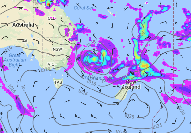
– Will this forecast eventuate? The long range map for March 8th shows wet, humid weather over the upper North Island while a high rolls over the lower South Island / weathermap
– WeatherWatch.co.nz
Comments
Latest Video

Cold weekend, frosts return with high pressure, then a low late next week
The subantarctic airflow spreads over NZ today/tonight and into Saturday, dropping temperatures nationwide. Snow flurries are possible today to lower…
Related Articles
Cold weekend, frosts return with high pressure, then a low late next week
The subantarctic airflow spreads over NZ today/tonight and into Saturday, dropping temperatures nationwide. Snow flurries are possible today to lower…

Wintry burst of weather: Snow, squally showers then sunshine & frosts
A polar change (another one!) arrives on Friday for the South Island and goes nationwide on Saturday, leaving NZ under…

Antarctic southerly for parts of NZ Fri & Sat
For the first time this year a southerly from off Antarctica is heading towards the South Island, followed by more…


Zelda on 27/02/2017 9:37pm
I do hope we get some more rain. Last evening’s rain not enough.
Signs of Autumn showing in some tree tops.
Weather Underground observations have been more accurate & wind direction better 🙂
SE clouds fan out this morning, a gentle SW breeze moves the foliage in my backyard.
A light blue patch shows West Auckland as the clouds begin to stir!
WW Forecast Team on 27/02/2017 9:47pm
Great to hear (re: Weather Underground). Yes some signs of Autumn now, the long nights will be helping with that too. Looks like Auckland may get wet weather during Weeks 2 & 3 of March. Lining up nicely right now, should know for sure by the weekend.
– Phil D