
> From the WeatherWatch archives
Not everyone has had snow, not everyone has had heavy rain but most regions have had strong, cold, winds this week as a nasty winter cyclone pushed past the South Island.
The storm, which rapidly developed on Monday night, was fairly small in size then – but over the past three days it has grown considerably, although the centre has weakened somewhat.
On Thursday evening the severe gales continued to hug the very south east and extreme east of the South Island – mostly Dunedin, Coastal Otago, the Catlins and Banks Peninsula.
WeatherWatch.co.nz readers said the gales – which lasted well over 24 hours in some places – felt “strong enough to lift the roof”.
However as the winds ease in Coastal Otago they will continue further north along the east of the North Island as the large low continues to slowly push them northwards.
Strong south to south west winds will clip exposed areas from Wellngton and Wairarapa to parts of Hawkes Bay, Mahia Peninsula and exposed parts of Gisborne – however at lesser speeds than what Dunedin experienced as the low very slowly weakens.
By Friday night winds will ease nationwide with gusty conditions limited only to the far east of the North Island.
.jpg)
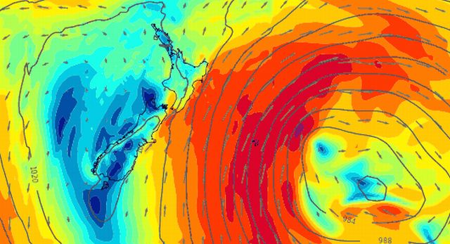
Thursday Afternoon – the purple indicates the belt of solid gale force winds just nicking the south east and far east of the South Island. The rest of country had strong/gusty winds indicated by orange and red.
Noon Friday and the blue colours indicate light winds, so a much calmer afternoon expected for Southland and Coastal Otago – but then the large low pushes strong winds into the eastern side of the North Island – however at a weaker level than what Dunedin faced yesterday.
Maps kindly provided by www.Weathermap.co.nz
– WeatherWatch.co.nz
Latest Video

Matariki, the long weekend + the outlook for next week
Wet weather and cloud continues along the eastern side of the country with the heaviest rain now moving into northern…
Related Articles
Matariki, the long weekend + the outlook for next week
Wet weather and cloud continues along the eastern side of the country with the heaviest rain now moving into northern…

More eastern rain, but a drier long weekend coming
Rain continues today along the eastern South Island and lower North Island, coming in from the east with heavy falls….

More heavy rain, snow – but large dry areas, especially as we go into the long weekend
Heavy rain will continue for parts of Canterbury and Marlborough over the next day or two and it will gradually…

