Some farmers are telling WeatherWatch.co.nz that parts of NZ now in a ‘Green Drought’
29/11/2017 7:46am

> From the WeatherWatch archives
SPECIAL REPORT — Farmers in Taranaki and Southland – and a handful of other places around New Zealand – are telling WeatherWatch.co.nz one thing right now: “We’re in a green drought”.
After a wet start to spring conditions have dramatically and quickly turned much drier and much hotter than average – and it’s likely to continue for another two weeks for many, even with these daily downpours this week.
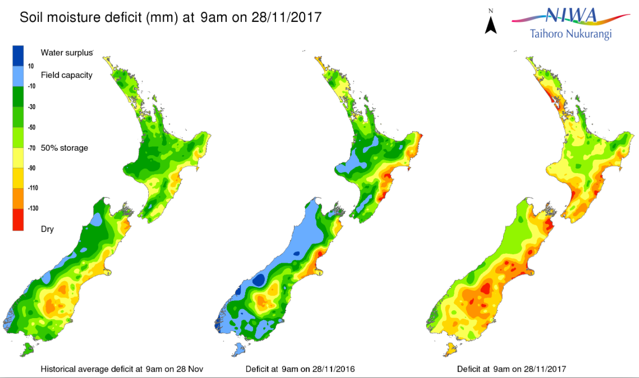
A ‘green drought’ is basically when grass on the farm is still green, but the ground below is hard and dry and water flows are drying up faster than rain bands are coming in. It’s basically a pre-cursor to an actual official drought declaration – although we’re still a very long way from that.
The current pattern is neutral – while a weak La Nina has been declared by some governments WeatherWatch.co.nz simply wants to remind New Zealanders last summer was a “weak La Nina” and it did not impact New Zealand at all despite Government Agencies saying we were in for a very long hot summer (which didn’t happen) and the news media which ran those headlines.
La Nina is measured at the equator – a very long way from New Zealand. If it’s officially “weak” and some Governments aren’t even currently recognising it, it seems (in our view) to be pointless to focus too much on it. Instead we need to focus on the local patterns between New Zealand, Australia and South Africa.
The current local pattern shows a trend of slow moving highs across the New Zealand area. The major downpours this week inland are a blessing for some people, but they are also mainly in National Parks and mountain ranges where most don’t live or work.
Compared to a year ago conditions are much drier.
In the view of WeatherWatch.co.nz forecasters we feel the current “big dry” is now officially “concerning”. Why? Because FARMERS are telling us “we are in a drought already” or “this is a bad start to summer”. We’re at a critical time.
CAN THIS BE REVERSED?
Yes! Don’t be too down just yet. The “neutral” season, or even a weak La Nina, means we have ‘chaotic’ weather and that can also mean, amongst the huge drying out phase in many regions, we have the chance of heavy rain events. For example – just look at this week. A huge high which is making dry conditions worse for so many lower lying areas – but a few have been very grateful for decent rainfall with perhaps a months worth of rain falling for some inland areas.
SO IS ALL OF NZ IS GOING INTO DROUGHT?
Not at all. In fact there areas that are concerning remain in “pockets”. But there are definitely some very concerning signs for so early in the dry season. Many regions are much drier than a year ago. The long range forecast may well be dry, but towards the middle of December there is some chance we may see more low pressure coming our way. The great thing about New Zealand is that one single low can actually reverse a drought. So we can always remain optimistic.
WE ARE TWO SMALL ISLANDS IN THE ROARING FORTIES – CHAOS IS HELPFUL!
The “Roaring 40s” is a belt of westerly winds that travel around the lower Southern Hemisphere, between Antarctica and up to the lower North Island. It’s the world’s most chaotic, empty, stretch of water and it sends truly mean and challenging weather further north. Sometimes highs and lows can dominate our tiny country (tiny on a global weather scale). So while the current big dry is concerning, the fact is just one big low or cold front (or a weird set up like this week with huge daily deluges) can reverse things. So you can remain optimistic.
Put another way, New Zealand’s weather isn’t locked in. We’re a bit like a “Wheel of Fortune” wheel that spins each and every week. It’s our job as weather forecasters to do our best to try and work out the new deal we’re dealt with each week and make the forecasts of rain as accurate as possible.
STAY POSITIVE!!
Yes, it’s dry now – but look at what a surprise this week has been. How often do you associate a “two week long anticyclone” with a week of downpours that may produce a months worth of rain? In other words, a “neutral” or “chaotic” pattern can be good for New Zealand, so too can a La Nina. It gives all farmer and growers great hope that relief may come in. We are not ruling out a chance of rain returning to New Zealand in the second week of December, but for now we’re being honest about just drier than normal it is.
LOW PRESSURE MAY RETURN TO NEW ZEALAND IN MID-DECEMBER
At this stage we think low pressure may move back into the New Zealand area for a while around the end of December’s second week and into the third. It is too far out to lock in though, but some models do show a large Tasman Sea low with sub-tropical connections.
TO CONCLUDE:
We’re not yet locked into a drought, but the “green drought” many farmers are telling us about is worth noting. We’re not focused on a “weak” La Nina that some Governments don’t even currently recognise. Instead, we’re hyper-focused on local patterns. We’ll keep you posted over the coming weeks.

– Image / Dec 11 – a possible low in the Tasman Sea / Weathermap.co.nz
– By Head Forecaster Philip Duncan, WeatherWatch.co.nz
Latest Video

Polar airflows set to bring cold weekend to NZ
Nor-west winds will be building over parts of NZ going into Thursday with rain on the West Coast becoming heavy…
Related Articles

NZ: Cold & windy, then calm & frosty
Downpours, some squally with the chance of thunderstorms and even small tornadoes are possible for parts of NZ over Friday…

WeatherWatch App launches real-time local lightning tracker
A bolt out of the blue! WeatherWatch has launched a live, real-time lightning tracker, enabling Kiwis to gain access to data provided by the…

Wind, rain, showers & a noticeable temperature drop for all
It will be a colder weekend right across NZ as a sub-Antarctic southerly blows through, bringing frosts, snow flurries and…

