> From the WeatherWatch archives
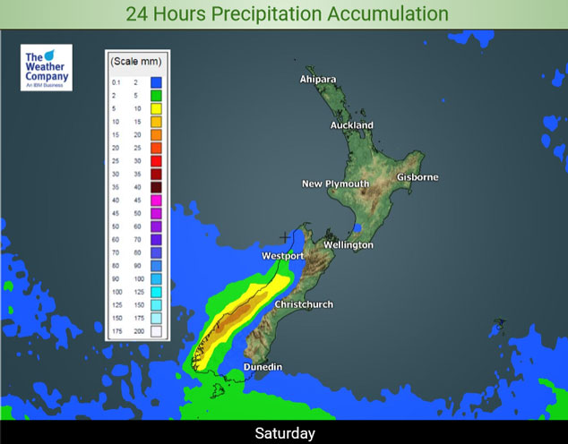
Expect a dry day for the North Island on Saturday, just a light shower or two may appear about Kapiti towards dawn on Sunday. The South Island sees a weakening front push northwards during the day binging rain to the west and mainly dry weather out east. A few showers push through Southland and perhaps Otago (mainly southern parts of Otago) as this change moves through.
In reference to the map below, mainly dry conditions till Wednesday next week for the North Island however from Monday afternoon an increasing northwesterly airflow starts to bring a few showers to the west. This concludes with a front moving through on Tuesday with an increased precipitation rate for a time then clearing away during the afternoon / evening. The precipitation about East Cape shown on the map below is from rain / showers that are occurring right now, they will clear this evening.
The bulk of the rain / showers showing for the West Coast of the South Island and Southland / Otago occurs on Monday next week, there is a chance a few showers may move into Canterbury too as a cool change moves through. Another front brings a period of rain or showers to South Westland and Southland / Otago on Tuesday then clearing away in the afternoon. Mainly dry for the rest of the South Island otherwise.

For rainfall accumulation maps for 1, 2 and 3 days out please visit our new maps page: https://www.weatherwatch.co.nz/maps-radars/rain/accumulative-rainfall
By Weather Analyst Aaron Wilkinson – WeatherWatch.co.nz
Latest Video

Antarctic southerly for parts of NZ Fri & Sat
For the first time this year a southerly from off Antarctica is heading towards the South Island, followed by more…
Related Articles
Antarctic southerly for parts of NZ Fri & Sat
For the first time this year a southerly from off Antarctica is heading towards the South Island, followed by more…

Meteors – Your Eyewitness Reports!
WeatherWatch.co.nz receives meteor reports from all over New Zealand and the globe, 24/7/365. **CASUAL COMMENTS**If you’ve seen something in the…

Snow, rain showers & cold polar southerlies set to return
Friday will be a wintry day across NZ as the next cold front arrives, bringing snow to lower levels of…

