Parts of NZ increasingly need rain – here’s the 7 & 14 day total rainfall outlooks (+Maps)
7/02/2019 1:31am

> From the WeatherWatch archives
With a big increase in tropical rainmakers developing to our north New Zealand has some fresh chances of getting rain in the coming weeks.
Large parts of New Zealand are now much drier than normal, this includes much of the upper and western North Island, the upper South Island and some parts of the eastern South Island.
There are some really sizeable rainmakers dancing around NZ but many of our driest regions may miss out to begin with. One positive that stands out is that it appears Northland may get some good rainfall should one of these tropical lows come in at the right angle. The data below suggests 100mm+ coming in the next couple of weeks for parts of Northland – but please note the fine line between heavy rain then almost none just a little further south.
WeatherWatch.co.nz says Central New Zealand will remain the driest part of NZ over the next two weeks.
Here are the 7 day and 14 day total rainfall accumulation maps, courtesy of GFS (US Government)…
7 DAY TOTAL RAINFALL OUTLOOK: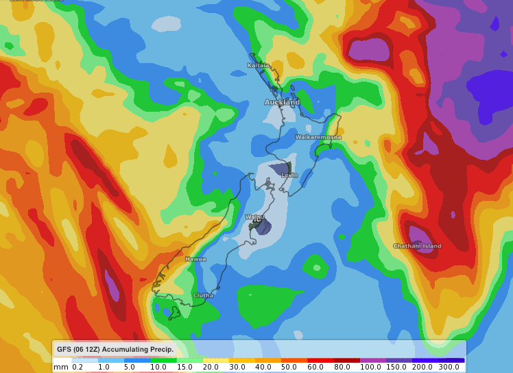
14 DAY TOTAL RAINFALL OUTLOOK:

– WeatherWatch.co.nz Exclusive
Latest Video

Wintry weather coming: Snow, rain, wind & sunshine
A cold front is moving into NZ from Friday to Sunday with low pressure developing west of NZ and then…
Related Articles

Polar airflow + northern low = pockets of heavy rain & snow
A colder change is coming – and so too is a large low which will develop and grow over northern…
Wintry weather coming: Snow, rain, wind & sunshine
A cold front is moving into NZ from Friday to Sunday with low pressure developing west of NZ and then…

ClimateWatch: JULY outlook & what El Niño means for NZ
El Niño is officially here and still getting stronger in the months ahead, but it’s harder to notice its effects…

