NZ’s big dry to get bigger and drier as high pressure blocks rainmakers (+7 & 14 day Total Rainfall Maps)
13/03/2019 11:59pm

> From the WeatherWatch archives
Rainmakers are definitely increasing around the New Zealand area but stubborn high pressure will continue to hold the rain clouds at sea for most (but not all) regions.
Over the next several days over 150mm of rain is forecast to fall out over the Tasman Sea, this is the biggest concentration of rain over that area so far this year – yet high pressure stuck over NZ may well keep the bulk of it offshore.
There are a couple of exceptions. The West Coast has a number of wet days ahead, but next week is looking dry there too. We may see a few more showers around the lower North Island too – but hit and miss.
The tropics is definitely waking up. A tropical cyclone is forecast to develop in the days ahead and likely impact Queensland, Australia next week. It’s unlikely this storm will come to NZ but we’ll be monitoring it closely and will have updates for those interested in tracking this storm. Our first update will be this morning.
There are other areas of low pressure forming north of NZ and around the Tasman Sea area too. But the stream of high pressure from south of Australia and directly crossing New Zealand looks set to continue for perhaps the rest of the month meaning things will get drier, before they get wetter again.
If high pressure in the NZ areas weakens then rain clouds look highly likely to move back in – so many will be hoping for that to happen at some point before the month is done.
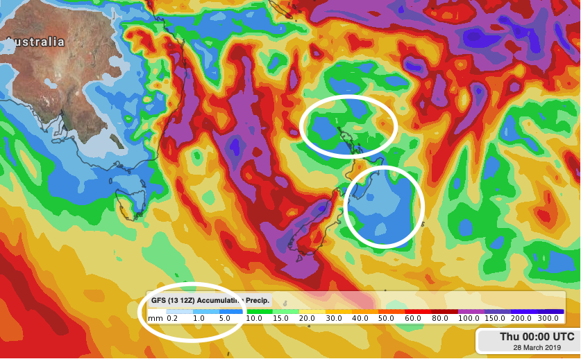
7 DAY TOTAL RAINFALL ACCUMULATION MAP
– Above – Based on GFS (US Govt)
– Below – Based on ECWMF (Europe)

14 DAY TOTAL RAINFALL ACCUMULATION MAP – GFS Only (US Government – please note being 14 days out means this will change a little, but you get the idea of where the heaviest rain will be and the driest weather will be).
– WeatherWatch.co.nz
Comments
Latest Video

Wintry burst of weather: Snow, squally showers then sunshine & frosts
A polar change (another one!) arrives on Friday for the South Island and goes nationwide on Saturday, leaving NZ under…
Related Articles
Wintry burst of weather: Snow, squally showers then sunshine & frosts
A polar change (another one!) arrives on Friday for the South Island and goes nationwide on Saturday, leaving NZ under…

Antarctic southerly for parts of NZ Fri & Sat
For the first time this year a southerly from off Antarctica is heading towards the South Island, followed by more…

Meteors – Your Eyewitness Reports!
WeatherWatch.co.nz receives meteor reports from all over New Zealand and the globe, 24/7/365. **CASUAL COMMENTS**If you’ve seen something in the…


Guest on 14/03/2019 4:08am
your forcasts don’t make sense if the highs are coming from SA how come areas between us in the bop and waikato are getting rain how can it be wet out east when they are after you so its an el nino the tropical season is resting on this forcast its a dud if its true
WW Forecast Team on 14/03/2019 6:41am
Hi there, firstly El Nino is climate, not a weather forecast so they are two different things. Secondly, highs don’t always bring dry weather. This one is centred north east of NZ so it’s pulling down humid air – this is creating drizzly patches/light showers in the morning and afternoon isolated downpours and thunderstorms for a minority of the North Island. Expect more of the same for another week but next week may be drier. With regards to El Nino, that was never going to be a driver of our weather this summer in our view but the stream of high pressure from south of Aussie is keeping things dry here – but around the edges we get showers and rain especially in between the highs.
Cheers
WW
Guest on 14/03/2019 2:30pm
el nino is encouraging lows to devolpe out east like it has at times in the past hence a lot of rain from the south