NZ (SUN): Cyclone Vaianu moves across the North Island
12/04/2026 5:03am
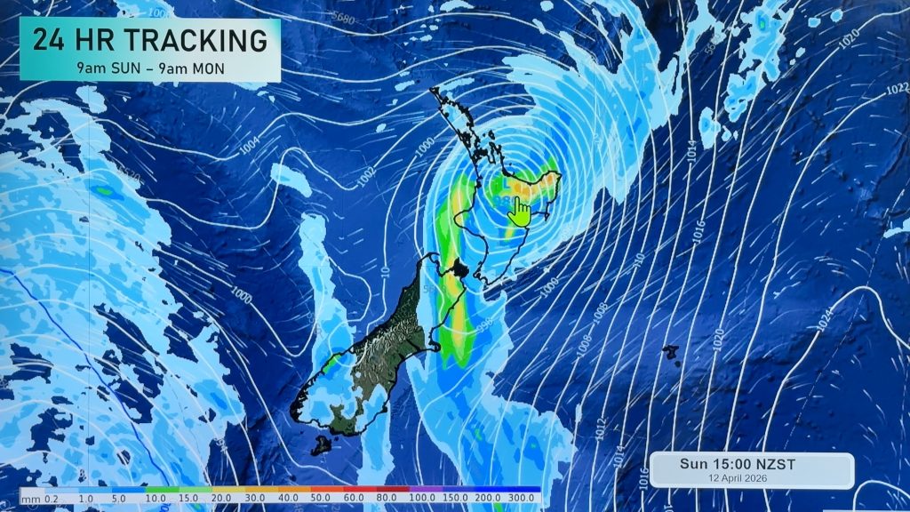
Cyclone Vaianu made landfall in Bay of Plenty this afternoon and is now moving into Hawke’s Bay, with the centre offshore from the North Island by around sunset.
Based on radar and satellite imagery the storm made landfall near Maketu (2pm). Landfall is when the centre of the storm tracks over land. The fast movement of Vaianu means landfall won’t weaken the storm much today, or overnight. But severe weather will shift to other parts of NZ as the storm quickly tracks south-east, followed by gale westerlies for a time, before quickly easing on Monday.
The video today focuses on the landfall – and what happens this afternoon, tonight/overnight and into Monday,
Earlier update:
Tracking of Cyclone Vaianu has shifted slightly eastwards today, reducing some severe weather in the west of the North Island but may be more intense now for the eastern BOP, East Cape and other parts of the north-eastern North Island.
Vaianu is expected to make landfall this afternoon in BOP and as it tracks over the North Island a strong to gale westerly change moves in behind it for northern and western parts of the North Island for a time, then that will spread east, replacing NE gales in eastern areas with NW gales tonight.
Heavy rain is also affecting the top of the South Island, around Tasman, Nelson and Marlborough with rain expected to continue today before easing, and more heavy rain and showers around parts of the North Island over the coming 24 hours.
By Monday daytime Vaianu’s centre will be east of NZ and by the end of Monday the storm is gone.
Keep up to date with MetService warnings and watches incase there are any further changes to the forecast today. The rain radar will be the most effective way to track the storm’s progress in real time today.
Comments
Latest Video

Matariki, the long weekend + the outlook for next week
Wet weather and cloud continues along the eastern side of the country with the heaviest rain now moving into northern…
Related Articles
Matariki, the long weekend + the outlook for next week
Wet weather and cloud continues along the eastern side of the country with the heaviest rain now moving into northern…

More eastern rain, but a drier long weekend coming
Rain continues today along the eastern South Island and lower North Island, coming in from the east with heavy falls….

More heavy rain, snow – but large dry areas, especially as we go into the long weekend
Heavy rain will continue for parts of Canterbury and Marlborough over the next day or two and it will gradually…


kimble bent on 12/04/2026 3:39am
Rain is falling in some places and not in others. Wind is varying.
Sharon on 12/04/2026 3:23am
Slight winds now no rain very humid in kaitaia northland.
Steven F on 12/04/2026 2:58am
Strong winds here in West Auckland since 1pm. No trees or branches down that I can see. No issues with power or water.
Eva on 12/04/2026 2:54am
Thanks Phil, looks like Wellington escapes with little drama. Just a normal day so far.
Roger on 12/04/2026 4:21am
Cloudy day with light showers so far.
Peter on 12/04/2026 2:37am
Thankyou
Sharon on 12/04/2026 2:13am
Excellent presentation. Thank you. This is exactly what MSM should be telling people facts without the catastrophisation!
Lisa on 12/04/2026 12:34am
Thanks for this very comprehensive forecast… appreciate it from Hawkes Bay.
Te Rangikaheke on 12/04/2026 12:32am
It’s when there is no commentary from the ‘experts’ ‘weather bureau’ and ‘media’ that we should worry. No news isnt necessarily good news in that case. But ‘everyone’ have done a great job caring for our hapori. Thankyou
Wendy on 12/04/2026 12:12am
Thank you! Really informative which I couldn’t find anywhere else.
View more comments